 Antiques (UK)
Africa Maps
Asia Maps
Australia/Oceania Maps
Celestial Maps
Central America/Caribbean Maps
Curiosities Maps
Digital Maps
Europe Maps
Map & Globe Mixed Lots
Map & Globe Reproductions
North America Maps
South America Maps
World & Celestial Globes
World Maps

-
$99.99 GBP

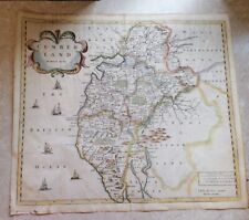
 🌟Antique Framed Robert Morden - Oxfordshire map circa 1722 "Frame 54cm X 62cm🌟
-
$200.00 GBP
 Antique 1801? FOLDING MAP ON A CLOTH A NEW MAP OF MIDDLESEX JOHN CARY
-
$129.99 GBP
 1695 JOHN MORDEN MAP CUMBERLAND CAMDENS BRITANNICA HAND COLOURED Swale Awnsham
-
$100.00 GBP
 Australian States Original 1873 Map Folio (6) Chapman And Hall +New Zealand
-
$100.00 GBP
 JAMES WYLD Antique 6 inches : 1 mile CLOTH MAP OF Ford, Shropshire
-
$4.00 GBP
 Bartholomew's NORTH YORKSHIRE COAST Half-Inch Sheet 36 - 1938 Vintage Cloth Map
-
$249.99 GBP
 1662 SCARCE WILLEM & JOAN BLEAU MAP DEVONSHIRE HAND COLOURED
-
$5.00 GBP
 Bartholomew's - CHESHIRE PLAIN - Half-Inch Sheet 12 - ?1920's Vintage Cloth Map
-
$4.99 GBP
 ORDSNANCE SURVEY OF SCOTLAND. KILLIN & LOCH RANNOCH. 1947 CLOTH MAP-NO. 55.
-
$150.00 GBP
 Durham & Northumberland Large John Cary Maps, 1821 Census, Town Distances
-
$5.00 GBP
 c1940s KENT County Road Map - Geographers Map Co
-
$46.54 GBP
 JAMES WYLD WYLD’s ANTIQUE CLOTH MAP OF STAFFORD 1891 19th CENTURY SCARCE
-
$29.99 GBP
 1673 MAP OF MONMOUTHSHIRE BY RICHARD BLOME WITH COLOUR CARTOUCHE MOUNMOUTHSHIRE
-
$90.00 GBP
 * Rare * Copperplate Engraved Map of Essex By John Seller Hand Coloured 1695
-
$52.00 GBP
 WINCARNIS MOTOR & CYCLIST MAP x13, c1920’s J Bartholomew, a BARGAIN at £4.00/ea
-
$28.00 GBP
 1900s double page map from g.w. bacon - cheshire !
-
$12.00 GBP
 Bacon's new chart of north and central England map
-
$3.50 GBP
 Bacons County Map Gloucester For Cyclists & Tourists c 1910 11
-
$20.00 GBP
 19th Century Map of Northamptonshire Edward Stanford HAND COLOURED Ordnance
-
$39.99 GBP
 Walker's DEVONSHIRE, antique folding map, J & C Walker circa 1840s, Devon
-
$3.99 GBP
 1970's BARTHOLOMEW HALF INCH MAP NORTH LANCASHIRE AND ISLE OF MAN
-
$9.99 GBP
 1748 A CORRECT MAP OF BRECKNOCKSHIRE IN SOUTH WALES BY OSBORNE CRICKHOWEL *
-
$80.00 GBP
 The Cornish Riviera c.1920's Fabulously Decorative Map By Hardings'
-
$19.99 GBP
 ANTIQUE FOLDOUT MAP OF BERKS, BUCKS & OXFORD, 1908 BACON'S NEW SURVEY, 2mls:1in
-
$7.99 GBP
 IRELAND 3 County Maps - Bartholomew's Revised Quarter-Inch Series V/G
-
$165.00 GBP
 1810 MAP Ordnance Survey of the Isle of Wight And part of Hampshire LARGE FORMAT
-
$95.00 GBP
 1832 CARY MAP Cardiganshire - Cardigan bay Merionethshire Wales LINEN HAND COL
-
$20.00 GBP
 c1910 Philips MAP of LIVERPOOL & DISTRICT N. Wales Manchester CLOTH 74cm x 100cm
-
$39.99 GBP
 E F Hudson , SCARCE ANTIQUE MAP , CYCLING MOTORING BIRMINGHAM AND NORTH WALES
-
$79.66 GBP
 Antique 1900s Maine Map Kennebec River City Of Bath Maine Lincoln County Map
-
$75.00 GBP
 Map Of Bagshot to Southampton By John Senex Coloured By Hand 1767
-
$145.00 GBP
 large 1900s bacons map of gloucester and wiltshire ( hardback boards )
-
$9.99 GBP
 19thC Surrey Antique County Map Cruchley Gall & Inglis Cyclist Tourist Railways
-
$9.95 GBP
 Bacon`s County Map and Guide For Cyclists & Tourists Nottingham
-
$3.50 GBP
 Bartholomew's revised half inch map of Kent - Cloth (map #10)
-
$17.99 GBP
 1910 The Courier Map of Dumfriesshire for cyclists, Motorists etc - Bartholomew
-
$115.00 GBP
 c1830 MAP Somersetshire Divided into Hundreds &c and the Parliamentary Divisions
-
$50.00 GBP
 Antique Map "Huntingdonshire" J & C Walker, 1846
-
$115.37 GBP
 RARE 1894 Colonial British New Guinea Large Map of Collingwood Bay & Cape Nelson
-
$28.00 GBP
 1900s double page map from g.w. bacon - salop n.
-
$99.00 GBP
 OS Maps Robert Dawson Collection of County Maps
-
$9.99 GBP
 Late 19thC Victorian Surrey Sussex Antique Folding Map Brighton Chain Pier Smith
-
$765.00 GBP
 Faden The Country Twenty-Five Miles Round London Slipcase Hand Coloured 1815
-
$33.00 GBP
 Bacon’s New Tourist Map of South Wales Names of Railway Stations ca1890
-
$9.00 GBP
 Bacon's County Map And Guide G.W. Bacon - Hampshire - 1900s
-
$6.00 GBP
 ORDNANCE SURVEY MAP THE POTTERIES SHEET 118 SHOWING PART OF THE NATIONAL PARK
-
$10.00 GBP
 Retro Vintage Cloth Map of Dartmoor , Bartholomews
-
$1250.00 GBP
 1757 Antique Folding Map: Rocque's Map of Middlesex
-
$19.99 GBP
 1897 North Riding Yorkshire Antique Map Dales Railway Hawes 118x71cm Bartholomew
-
$200.00 GBP
 c1820 MAP Cornwall From a recent Survey With the Railways SCARCE ORIGINAL Linen
-
$7.99 GBP
 Vintage Bartholomew's Map of Suffolk (1962) Sheet 21 - Folding Cloth County Map
-
$29.95 GBP
 1789 LARGE ANTIQUE COPPER PLATE MAP - DURHAM - JOHN HARRISON
-
$2.80 GBP
 Bartholomew's Vintage Map Of Warwickshire
-
$5.00 GBP
 1912 Cycling Road MAP 50 Miles Around LONDON - VG Cond
-
$2.75 GBP
 BARTHOLOMEW'S NEW REDUCED SURVEY TOURISTS & CYCLIST SHEET 6 DUBLIN AND ATHLONE
-
$29.95 GBP
 1787 LARGE ANTIQUE COPPER PLATE MAP - MIDDLESEX LONDON - JOHN HARRISON
-
$50.00 GBP
 Antique Map "Worcestershire" J & C Walker, 1846
-
$6.00 GBP
 ORDNANCE SURVEY MAP MINEHEAD and BRENDON HILLS SHEET 181 c1979 FIRST SERIES VGC
-
$4.99 GBP
 Ordnance Survey No 124 1931 Guildford and Horsham cloth bound
-
$750.00 GBP
 1830 Map of the County Palatine of Lancaster Lancashire HENNET 162x115cm 64"x45"
-
$7.99 GBP
 Vintage Bartholomew's Map of DORSET (1968) Sheet 4 Folding County Cloth Map
-
$10.00 GBP
 Antique Vintage Ordnance Survey Contoured Road Map No 53 DERBY 1921
-
$9.99 GBP
 1903 Antique Map; Bristol, Stroud, Monmouth, Newport Environs. John Bartholomew
-
$55.00 GBP
 1794 Map of Cheshire Original Antique Map by John Stockdale
-
$15.00 GBP
 c.1902 Bacon's COUNTY MAP of LEICESTER & RUTLAND
-
$50.00 GBP
 Antique Map "Northamptonshire" J & C Walker, 1835
-
$7.00 GBP
 THE TIMES Contour Road Map of Hampshire, Dorset, Wiltshire & Adjacent Counties
-
$3.50 GBP
 Bartholomew's Cloth Map Of Oxfordshire
-
$45.00 GBP
 Antique Map "Buckinghamshire" J & C Walker, 1845
-
$1.99 GBP
 1898, Antique Map Aurillac, France, Ministere De L'Interrieur, Hatchette & Co
-
$19.99 GBP
 Antique Map BRITISH ISLES c1850 Salmon & Wallis J.Rapkin engraved original
-
$175.00 GBP
 c1850 Wyld Kent Reduced Ordnance Survey Faden Mudge Large 96x65cms Antique Map
-
$6.00 GBP
 ORDNANCE SURVEY BUXTON, MATLOCK and DOVE DALE MAP SHEET 119 c1979 NATIONAL PARK
-
$8.99 GBP
 BELGIUM ORIGINAL ANTIQUE MAP 1910 EUROPE CARTE
-
$12.99 GBP
 Philips' County Map of Bedfordshire c1895 Colour Folding Sheet, Ordnance Survey
-
$55.00 GBP
![[Kent] Bacon's Twentieth Century Map of Kent c.1901 Folding Linen Backed](https://i.ebayimg.com/thumbs/images/g/ScYAAOSwdYNi171y/s-l225.jpg) [Kent] Bacon's Twentieth Century Map of Kent c.1901 Folding Linen Backed
[Kent] Bacon's Twentieth Century Map of Kent c.1901 Folding Linen Backed
-
$50.00 GBP
 Antique Map "Gloucestershire" J & C Walker, 1845
-
$10.00 GBP
 c1920 Geographia LIVERPOOL & MANCHESTER District LINEN MAP - VG Cond Cloth
-
$3.25 GBP
 Vintage/Antique "Geographia" Large Scale Road Map, Peak District & Derby Dales
-
$7.99 GBP
 Vintage Bartholomew's Map of Mid Wales (1964) Sheet 22, Welsh Folding Cloth Map
-
$12.00 GBP
 BARTHOLOMEW'S NEW REDUCED SURVEY TOURISTS & CYCLIST SHEET 6 DUBLIN AND ATHLONE
-
$10.00 GBP
 c1910 Bartholomew's LIVERPOOL to MANCHESTER MAP For Tourists & Cyclists Linen #8
-
$19.50 GBP
 C1912 Bacon's Road-Map for Cycling & Motoring Bradford District (Leeds, Ilkely)
-
$600.00 GBP
 1874 V. Large MAP North of England With County of Durham 146cm x 131cm SCARCE
-
$60.00 GBP
 c1900 Deighton's Cycling Driving Touring Hunting Map 25 Miles Worcester RARE
-
$7.99 GBP
 Vintage Bartholomew's Map of Sussex (1966) Sheet 6 - Folding Cloth County Map
-
$14.95 GBP
 1760 ORIGINAL COPPER PLATE ANTIQUE MAP BRANDENBURG BERLIN GERMANY - JOHN GIBSON
-
$8.99 GBP
 TUNISIA TUNISIE ORIGINAL ANTIQUE MAP 1923 NORTH AFRICA CARTE TUNISIE ORIENTALE
-
$7.50 GBP
 Larbys new series of district maps Norwich
-
$42.00 GBP
 Bacon's Map of North Wales From Ordnance Surveys Names of Railway Stations 1890
-
$10.00 GBP
 Geographica numbered road Touring Map No 2 South West Counties
-
$28.00 GBP
 1900s double page map from g.w. bacon - worcestershire & gloucestershire 45
-
$11.95 GBP
 1761 ORIGINAL COPPER PLATE ANTIQUE MAP SAXONY BOHEMIA GERMANY - JOHN GIBSON
-
$8.99 GBP
 BRUGES BELGIUM ORIGINAL ANTIQUE MAP 1910 TOWN PLAN EUROPE CARTE
-
$28.00 GBP
 1900s double page map from g.w. bacon - monmouth !
-
$6.00 GBP
 ORDNANCE SURVEY MAP BARNSTAPLE and ILFRACOMBE 1ST SERIES SHEET 180 c1974 VGC
-
$700.00 GBP
 Faden The Country Twenty-Five Miles Round London Slipcase Hand Coloured 1815
-
$20.00 GBP
 Vintage 1952 map of Oslo, Oslofjord, Norway. 1:200 scale
-
$25.00 GBP
 Original Antique Sketch Map of North East Yorkshire 1904 13.75" x 10.5"
-
$79.70 GBP
 Road Map of Lee County, Iowa ~ Undated ~ est. early 1900s ~ Condition Acceptable


