 Antiques (UK)
Africa Maps
Asia Maps
Australia/Oceania Maps
Celestial Maps
Central America/Caribbean Maps
Curiosities Maps
Digital Maps
Europe Maps
Map & Globe Mixed Lots
Map & Globe Reproductions
North America Maps
South America Maps
World & Celestial Globes
World Maps

-
$40.00 GBP

 Antique Medco Elementary Atlas Comparative Geography Map Book Coloured Plates
-
$120.00 GBP
 Cram’s 12" Unrivaled Terrestrial Globe Made By The George F. Cram Co. Indianna
-
$99.95 GBP
 EUROPEAN AIR ROUTES & EXTENSIONS 1931 LARGE VINTAGE AVIATION AIRLINE ROUTE MAP
-
$38.33 GBP
 VINTAGE 1934 Map INDIANA County Township Railroads Indianapolis South Bend
-
$52.00 GBP
 Vintage 1930s Small Tin Rotating World Globe on Base J. Chein & Co
-
$12.50 GBP
 1931 Vintage/Antique 'Tunbridge Wells' War Office Ordnance Survey Map, No 125
-
$42.49 GBP
 Vintage Map of London & Suburbs 1932 Bacon`s New Large Print 1s.6d Antique
-
$185.00 GBP
 1930s Terrestrial Globe German 10" Wooden Stand
-
$20.00 GBP
 ORIGINAL 1930’S KINGSBRIDGE CHARLETON COURT ESTATE PROPOSED BUILDING LAYOUT
-
$185.00 GBP
 1934 Cecily Peele Map of Oxford and Her Worthies - Hand Painted In Colour 1948
-
$12.00 GBP
 Stanford's 1930s Map of Canals & Rivers Navigable by Small Craft
-
$11.99 GBP
 VINTAGE 1930 HULL CITY PLAN Colour Map - Mounted For Framing
-
$5.50 GBP
 Merseyside 1934 Bartholomew's Revised Half Inch Contoured Map Sheet 8
-
$42.43 GBP
 1934 COLORADO Map County Township Railroads Denver Aspen Arvada Brighton Creede
-
$38.33 GBP
 1934 Map MISSISSIPPI County Township Railroads Jackson Gulfport Meridian Biloxi
-
$44.83 GBP
 1934 Map NEW JERSEY County Township Railroads Hoboken Atlantic City Fort Hancock
-
$7.99 GBP
 VINTAGE 1930 DUNDEE CITY PLAN Colour Map - Mounted For Framing
-
$22.00 GBP
 “Plan of Central London” 1939 Vintage Map 61X46cm
-
$7.59 GBP
 ORDNANCE SURVEY CLOTH ANTIQUE UK MAP 1926 PEEBLES AND GALASHIELS
-
$9.99 GBP
 VINTAGE 1930 LANDS ENDS CORNWALL AREA PLAN Colour Map - Mounted For Framing
-
$15.00 GBP
 Vintage Italian Map 1930's Touring Club Milano
-
$18.99 GBP
 Old Map of Redditch (S), Headless Cross, Warwickshire -1938- Repro 30 SE
-
$12.00 GBP
 Vintage map of UK BRITAIN ENGLAND BRITISH ISLES - 1930s, approx A3 size - VGC
-
$19.99 GBP
 1958 Antique Map; Admiralty Chart # 2164 Firth Of Clyde To Large Channel
-
$12.00 GBP
 Vintage map of BALI INDONESIA EAST INDIES PHILIPPI - 1930s, approx A3 size - VGC
-
$9.95 GBP
 Map 1935: Soviet Union European Territory, Poland East Prussia Lithuania #17/2
-
$4.99 GBP
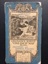 Hertford and Saffron Walden 1938 cloth Ordnance Survey map sheet 96, 1” series
-
$7.50 GBP
 Map 1935: China Japan & Korea Print Maps Original Vintage #31
-
$35.13 GBP
 1931 NORTH CAROLINA Map ORIGINAL Virginia Pamlico Sound Washington DC Maryland
-
$80.00 GBP
 Vintage Ordnance Survey Map Alston & Weardale
-
$29.62 GBP
 1934 Map LOUISIANA County Township Railroads New Orleans Shreveport Monroe
-
$38.33 GBP
 New York State Map 1934 ORIGINAL County Township Brooklyn Long Island City Erie
-
$200.00 GBP
 1935 Original Vintage Rare LONDON UNDERGROUND TUBE MAP No 2 Harry BECK
-
$7.50 GBP
 Map 1935: New Zealand ( North Island) New South Wales Victoria South Australia
-
$80.00 GBP
 bartholomew geographical society 1939 SURVEY ATLAS england wales maps plans
-
$11.99 GBP
 VINTAGE 1930 GLASGOW CITY PLAN Colour Map - Mounted For Framing
-
$11.99 GBP
 VINTAGE 1930 YORK CITY PLAN Colour Map - Mounted For Framing
-
$9.99 GBP
 CENTRAL LIVERPOOL CITY PLAN - 1930 Antique Map by Bartholomew
-
$88.06 GBP
 VINTAGE 1936 LAKE ERIE BEACH, NEW YORK MAP! CANVAS BACKED! ERIE COUNTY,NY 46x16"
-
$29.62 GBP
 1934 Map WISCONSIN County Township Railroads Madison Lake Superior Milwaukee
-
$18.99 GBP
 Brompton Pimlico Westminster Map London 1932 #75-76
-
$11.99 GBP
 VINTAGE 1930 PORTSMOUTH CITY PLAN Colour Map - Mounted For Framing
-
$5.00 GBP
 Bartholomew's SUSSEX Half-Inch Sheet 32 - 1933 Vintage Cloth Map
-
$17.99 GBP
 Old map Folkestone (N), Hawkinge, Arpinge OS Kent 75-NW-1938 A2
-
$99.95 GBP
 EUROPEAN AIR ROUTES & EXTENSIONS 1936 LARGE VINTAGE AVIATION AIRLINE MAP
-
$7.99 GBP
 LAKE DISTRICT, CUMBRIA, WESTMORLAND - 1930 Antique Map by Bartholomew
-
$11.99 GBP
 VINTAGE 1930 MANCHESTER CITY PLAN Colour Map - Mounted For Framing
-
$18.99 GBP
 Old Map of Walsall ( NE), Aldridge,(W), Rushall, Staffs in 1938- Repro 63 NE
-
$11.99 GBP
 VINTAGE 1930 NORWICH CITY PLAN Colour Map - Mounted For Framing
-
$9.99 GBP
 VINTAGE 1930 LIZARD POINT CORNWALL AREA PLAN Colour Map - Mounted For Framing
-
$14.99 GBP
 Vintage Bacon’s County Map of Yorkshire c.1930’s
-
$6.99 GBP
 LYME REGIS ,SEATON BAY & District - Vintage Folding Map 1938
-
$9.30 GBP
 W & AK JOHNSTONS CLOTH ANTIQUE UK MAP BERWICK ON TWEED WARK BLYTH CHEVIOT HILLS
-
$175.00 GBP
 Original Map "Railway Map. No. 2. 1934." (London Tube Map) Henry C. Beck
-
$14.99 GBP
 The Lake District Vintage Map C1930's For Pedestrians On Cloth Bartholomew's
-
$18.99 GBP
 Old Map of Wolverhampton ( SW ), Upper Penn, Staffordshire in 1938- Repro 62 SW
-
$5.99 GBP
 HASTINGS, EASTBOURNE & District - Vintage Folding Map 1932
-
$7.99 GBP
 ANTIQUE 1910 CHICHESTER CATHEDRAL PLAN Map - Mounted For Framing
-
$18.99 GBP
 Old Map of Bushbury ( W ), Codsall ( E ), Staffordshire, in 1938- Repro 56 SW
-
$85.00 GBP
 1939 Town Plan of Belfast Ordnance Survey 8 inches to mile
-
$18.99 GBP
 Wood Green (E), Tottenham Map London 1932 #31-32
-
$18.99 GBP
 Walton-upon-Thames, Esher in 1938 - old map Surrey 12-SW
-
$18.99 GBP
 Bradford on Avon, Winsley, old map Wiltshire 1938: 32SW repro
-
$18.99 GBP
 Sanderstead (east), Selsdon, Farleigh in 1938 - old map Surrey 20-NE
-
$11.99 GBP
 VINTAGE 1930 LEEDS CITY PLAN Colour Map - Mounted For Framing
-
$18.99 GBP
 Skelmanthorpe, Clayton West, old map Yorkshire 1938: 261SE repro
-
$4.99 GBP
 CHESTER Town Plan Vintage Map c1935
-
$11.99 GBP
 VINTAGE 1930 CAMBRIDGE CITY PLAN Colour Map - Mounted For Framing
-
$18.99 GBP
 Regents Park, Mayfair area Old Map London 1932 #59-60 Repro
-
$11.99 GBP
 VINTAGE 1930 BRISTOL CITY PLAN Colour Map - Mounted For Framing
-
$6.00 GBP
 ORIGINAL VINTAGE : GEOGRAPHIA LARGE SCALE STREET PLAN OF ROCHDALE
-
$18.99 GBP
 Goole, Airmyn, old map Yorkshire 1938: 237SE repro
-
$18.00 GBP
 Jan 1938 GERMANY Austria & Switzerland CLOTH BACKED FOLDING MAP John Bartholomew
-
$9.99 GBP
 Antique 1930s London Map - Mounted - Colour - WIMBLEDON, MERTON, MORDEN 29
-
$18.99 GBP
 Wootton (S), Wootton Green, Shelton, old map Bedfordshire 1938: 16SW
-
$18.99 GBP
 Chiswick, Barnes, North Sheen, Fulham Workhouse in 1933 - old map Surrey 2-SW
-
$18.99 GBP
 Old Map of Redditch Warwickshire -1930- Repro 30 NE
-
$9.99 GBP
 VINTAGE 1930 LOCH LOMOND & TROSSACHS Colour Map - Mounted For Framing
-
$5.95 GBP
 A4 Reprint of Old Maps Hollywood Stars Map Stamped 1937 Highly Detailed
-
$40.02 GBP
 5 Antique 1920’s/1940's LONDON ENGLAND MAPS/GUIDE BOOKS/ATLAS Paper/Cloth Travel
-
$12.37 GBP
 World Natural Vegetation & Temperature 1938 Original Antique Map
-
$7.99 GBP
 VINTAGE 1930 LLANDUDNO & CONWAY DISTRICT PLAN Colour Map - Mounted For Framing
-
$11.99 GBP
 VINTAGE 1930 SWANSEA CITY PLAN Colour Map - Mounted For Framing
-
$10.00 GBP
 ORDNANCE SURVEY MAP. 1932. 1/2 to 1 inch. SOUTHAMPTON, PORTSMOUTH, IOW. LINEN
-
$12.99 GBP
 ENGLISH COUNTY MAPS of SURREY ~ ROYAL GEOGRAPHICAL SOCIETY SHEET 7 1932
-
$39.99 GBP
 National Geographic Map - Africa - 1935 - with Index Booklet - Vintage
-
$15.00 GBP
 Lovely Vintage Map of Footpaths & Bridle Roads on The Charnwood Forset 1935 A894
-
$18.99 GBP
 Old map Brightlingsea (SW, East Mersea, Essex 1938 (48SW)
-
$11.99 GBP
 VINTAGE 1930 WINCHESTER CITY PLAN Colour Map - Mounted For Framing
-
$14.99 GBP
 Antique Map Of The Eastern Highlands (SCOTLAND)
-
$18.99 GBP
 Old Map of Huntington, New Earswick, Yorkshire -1931 - Repro 157 SE
-
$14.50 GBP
 Vintage WW2 war map Lowestoft Sht 77 Cloth back own by Brigadier HG Howson 1932
-
$5.00 GBP
 Brtholomew's Street Index Plan of London - North-East Section c1930
-
$14.50 GBP
 Vintage WW2 war map DEVIZES sheet 112 cloth back Brigadier HG Howson 1932
-
$3.99 GBP
 CIRCA 1930'S GEOGRAPHIA LARGE SCALE PAPER ROAD MAP OF 50 MILES ROUND BOURNEMOUTH
-
$8.00 GBP
 London- River Thames Entrance 1932 Antique Map, Admiralty Chart 1605
-
$16.97 GBP
 Dominion of Canada with Newfoundland 1930 Original Antique Map
-
$7.99 GBP
 VINTAGE 1930 AYR CITY PLAN Colour Map - Mounted For Framing
-
$120.09 GBP
 Story Map of Mexico, Pub. by Colortext Publications Chicago, Ill 1939. 17x22 in.
-
$21.99 GBP
 Antique Map: Portsmouth, Hampshire, Mounted , c1920 Portsea Island


