 Antiques (UK)
Africa Maps
Asia Maps
Australia/Oceania Maps
Celestial Maps
Central America/Caribbean Maps
Curiosities Maps
Digital Maps
Europe Maps
Map & Globe Mixed Lots
Map & Globe Reproductions
North America Maps
South America Maps
World & Celestial Globes
World Maps

-
$59.99 GBP

 Original 1930 Pratts High Test Map of The Great North Road
-
$25.00 GBP
 1933 Vintage Folding Guide Map Inverness & Caledonian Canal Scotland 12.5" x 10"
-
$79.66 GBP
 Antique 1900s Maine Map Kennebec River City Of Bath Maine Lincoln County Map
-
$25.00 GBP
 Old Folding Plan of Central London 1930 Section 2 Ward Lock & Co 33" x 6.75"
-
$10.00 GBP
 Vintage National Geographic Map Of The United States 1933
-
$4.00 GBP
 Bartholomew's NORTH YORKSHIRE COAST Half-Inch Sheet 36 - 1938 Vintage Cloth Map
-
$5.00 GBP
 Bartholomew's SUSSEX Half-Inch Sheet 32 - 1933 Vintage Cloth Map
-
$5.00 GBP
 Bartholomew's DARTMOOR Half-Inch Sheet A2 - 1937 Vintage Dissected Cloth Map
-
$12.00 GBP
 ORDNANCE SURVEY 1" TO 1 MILE TOURIST MAP OF THE NEW FOREST c1930
-
$29.99 GBP
 Vintage Contoured Map The Lake District Cumbria Windermere CLOTH BACKED 1930s
-
$49.99 GBP
 Vintage Map of London & Suburbs 1932 Bacon`s New Large Print 1s.6d Antique
-
$120.00 GBP
 Map "Massif de Gavarnie et du Mont Perdu" (Gavarnie-France) Franz Schrader, 1932
-
$7.50 GBP
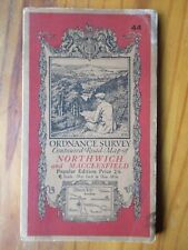 1933 Ordnance Survey NORTHWICH and MACCLESFILED Vintage Cloth Map No.44
-
$70.93 GBP
 PICTORIAL MAP - 1939 Otto Muller Large SWITZERLAND Original illustrated chart
-
$119.62 GBP
 1930 Large Map INDIA PROVINCES ADMINISTERED BY CHIEF COMMISSIONERS Stanford
-
$25.00 GBP
 1932 Vintage Folding Guide Map Snowdonia Pwllheli Criccieth Wales 12.5" x 11"
-
$5.00 GBP
 Brtholomew's Street Index Plan of London - North-East Section c1930
-
$6.95 GBP
 GEOGRAPHIA LARGE SCALE PAPER ROAD MAP OF 50 MILES ROUND BOURNEMOUTH - C. 1930
-
$7.95 GBP
 GEOGRAPHIA 2":1 Mile FOOTPATH MAP OF COUNTRY AROUND EASTBOURNE - 1938
-
$7.99 GBP
 Vintage Ordnance Survey Map of Briton and Eastbourne 134 - 1920
-
$10.50 GBP
 Ordnance Survey Tourist Map of The Lake District 1930s - cloth webbed map
-
$37.00 GBP
 ORIGINAL Pratts High Test Map of The Great North Road Alfred E Taylor 1930 38X93
-
$3.99 GBP
 1970's BARTHOLOMEW HALF INCH MAP NORTH LANCASHIRE AND ISLE OF MAN
-
$4.99 GBP
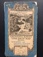 Hertford and Saffron Walden 1938 cloth Ordnance Survey map sheet 96, 1” series
-
$8.00 GBP
 Bartholomew's one inch map of The Lake District c1930s
-
$10.00 GBP
 WAR OFFICE 1933 MAP of ALDERSHOT COMMAND Ordnance Survey Map
-
$55.00 GBP
 1938 Linen Backed STREET MAP of LONDON by Alexander Gross BOUND IN CLOTH
-
$40.00 GBP
 1933 Pictorial Plan of London by Geographia In Original Guide
-
$38.50 GBP
 OFFIZIELLE STRASSENZUSTANDSKARTE DES OSTEREICHISCHEN TOURING CLUB MAP JUNI 1930
-
$9.56 GBP
 Map 1930 Seat Of Revolutionary War c1775-1780 10.5 x 9" Offset Lithograph DWEE2
-
$103.57 GBP
 1939 Arkansas Folding Highway System Road Map Pictures Points of Interest
-
$118.75 GBP
 Berlin City Street Map 1936 - Size 24x32" Olympia w/ Reichssportfeld + Potsdam
-
$8.00 GBP
 Ordnance Survey Contoured Road Map of Bolton and Manchester, No. 36
-
$950.00 GBP
 1933: London Underground Map - September 1933
-
$12.99 GBP
 1932 WAR OFFICE MAP - LLANDRINDOD WELLS WALES - LMS GWR RAILWAY
-
$14.00 GBP
 Ordnance Survey 1/4" Map Fourth Edition Sheet 8 Midlands
-
$8.00 GBP
 1930's Bartholomew's Sheet 10 Lincoln Wolds colour. Two inch to mile on cloth.
-
$5.00 GBP
 1933 CASTLE DOUGLAS & KIRKCUDBRIGHT Ordnance Survey WAR ISSUE Cloth Map
-
$23.91 GBP
 Rand McNally Fold-Out Linen Backed Standard Map of USA~ca. 1930~ 39.5" x 28"
-
$19.99 GBP
 VINTAGE ADMIRALTY NAUTICAL CHART 1818 ‘Channels Between USHANT and the MAINLAND’
-
$30.00 GBP
 c.1930's Blake's Folding Map of the Rivers & Broads of Norfolk & Suffolk
-
$5.00 GBP
 1931 NORWICH & GREAT YARMOUTH Norfolk - Ordnance Survey Contoured Cloth Map #67
-
$20.00 GBP
 Marlborough & Devizes Ordance Survey 1 inch to 1 mile Road Map Sheet 112 - 1930
-
$5.00 GBP
 Bartholomew's TYNESIDE Half-Inch Sheet 2 - 1933 Vintage Cloth Map
-
$7.99 GBP
 Vintage Motoring & Touring Map (c1930) Bath, Barry, Bristol, Cardiff, Newport, H
-
$2.80 GBP
 Bartholomew's Vintage Map Of Warwickshire
-
$14.00 GBP
 Ordnance Survey 1/4" Map Fourth Edition Sheet 2 North Central Ise of Man
-
$7.99 GBP
 Vintage Motoring & Touring Map (c1930) Aylesbury, Devizes, Newbury, Oxford - J
-
$6.00 GBP
 Ordnance Survey 'One-Inch Map on cloth', Bournemouth &Weymouth, circa 1939.
-
$7.99 GBP
 Topographischer Atlas der Schweiz FINSTERAARHORNGEBIET 1 : 50 000 (1930) Old Map
-
$5.00 GBP
 1931 WINDSOR Berkshire - Ordnance Survey Contoured Cloth Map #114
-
$7.99 GBP
 Vintage Ordnance Survey Map of Barnstable and Exmoor 118 - 1919
-
$7.50 GBP
 1936 Ordnance Survey BARNSTABLE Vintage Cloth Map No.118
-
$14.99 GBP
 Chichester (c1937) Vintage Ordnance Survey Tourist Map - West Sussex, England
-
$7.49 GBP
 Readyfold Coloured Touring Map, c1930 - Johnston's - Section 8, Midlands
-
$4.99 GBP
 Ordnance Survey No 124 1931 Guildford and Horsham cloth bound
-
$7.50 GBP
 WAR OFFICE 1934 EAST KENT Ordnance Survey Canvas Map
-
$7.99 GBP
 CHANNEL ISLANDS ENGLISH CHANNEL original old antique map c1930s carte NORMANDY
-
$17.26 GBP
 Vintage Philips Railway Map of the British Isles by George Philip Son Ltd c1930
-
$9.99 GBP
 1951 Bartholomew's Revised 1/4 inch Map of Ireland. Sht 2 Dublin and Roscommon
-
$14.99 GBP
 1930 Geographia Large Map of Southern Scotland and Adjacent English Counties
-
$14.99 GBP
 Truro & St Austell (1934) Vintage Ordnance Survey Relief Edition Map, Cornwall
-
$9.99 GBP
 Vintage Folding Cloth Map of Southern England (1934) Ordnance Survey, Dissected
-
$7.00 GBP
 THE TIMES Contour Road Map of Hampshire, Dorset, Wiltshire & Adjacent Counties
-
$3.50 GBP
 Bartholomew's Cloth Map Of Oxfordshire
-
$6.99 GBP
 1931 Ordnance Survey Folding Map mile=1 inch. Popular Edition. North East Wales
-
$8.00 GBP
 BLACKPOOL & DISTRICT Geographia 2 Miles to Inch - Cloth Road Map VG Cond c1930s
-
$5.00 GBP
 Bartholomew's WARWICKSHIRE Half-Inch Sheet 18 - 1936 Vintage Dissected Cloth Map
-
$7.99 GBP
 Vintage Motoring & Touring Map (c1930) Birmingham, Derby, Coventry, Rugby - E
-
$7.25 GBP
 STANFORD'S 1":2 MILE LINEN BACKED DISSECTED MAP - DORSET & WEST - C. 1930
-
$9.99 GBP
 1940 Bartholomew's Revised 1/4 inch Map of Ireland. Sht 6 Dublin and Athlone
-
$104.03 GBP
 WW2 WWll Japanese Map of Shanghai China 1932 Showa 7 / Original Print Photo
-
$10.00 GBP
 WAR OFFICE 1931 BRECON & LLANDOVERY Ordnance Survey Canvas Map - Wales - VG Cond
-
$7.50 GBP
 1933 READING & NEWBURY Ordnance Survey Cloth Map - 1 inch to 1 Mile
-
$19.99 GBP
 Vintage Map of England & Wales (c1930s) North/South, London Inset, Road & Rail
-
$80.00 GBP
 GERMANY LARGE ORIGINAL FOLDING Map X2
-
$6.00 GBP
 1930 Bartholomew's CENTRAL WALES - Half-Inch Sheet 16 Vintage Cloth Map
-
$120.00 GBP
 c.1935 Guide Map of Jerusalem by Bernhard Gauer
-
$9.99 GBP
 Vintage Bartholomew Folding Map; York & Scarborough (c1930s) Stanford Motoring 7
-
$32.00 GBP
 Vintage Foldable Map of Lake of Lucerne Switzerland & Local photos 1930 - 40s
-
$15.00 GBP
 Vintage 1941 National Geographic: Atlantic Ocean Insert Map - Gilbert Grosvenor
-
$9.99 GBP
 Vintage Bartholomew Folding Map; Cheshire (c1930s) Stanford Motoring, Cycling 12
-
$14.99 GBP
 Youth Hostels in England and Wales 1944 - Vintage Ordnance Survey Folding Map
-
$9.99 GBP
 Vintage Bartholomew Folding Map; Bedford Hertford, N London (c1930s) Stanford 25
-
$62.00 GBP
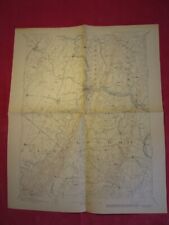
 Bundle Of 7 Ordnance Survey Maps 30s Linen Backed 1-inch To 1 Mile
-
$8.95 GBP
 G.W. BACON ENGLAND & WALES NORTH & SOUTH REVERSIBLE MAP - 1931
-
$21.50 GBP
 OLD VINTAGE MAP FLORIDA USA c1930 NATIONAL GEOGRAPHIC by WILLIAMS & HEINTZ
-
$14.99 GBP
 Ordnance Survey Map of Torquay (1937) Folding Cloth One Inch Map, Devon, O/S
-
$8.99 GBP
 Readyfold Coloured Touring Map, c1930 - JOHNSTON - Section 8, Midlands
-
$8.77 GBP
 Shell Map of metropolitan Boston and Cape Cod 1939 vintage
-
$78.11 GBP
 1931 Map Of Kentucky w/ Booklet BEAUTIFUL!! Full Color Antique Map
-
$7.99 GBP
 SAINT PETER PORT GUERNSEY original old antique map c1930s CHANNEL ISLANDS carte
-
$9.99 GBP
 Vintage Bartholomew Folding Map; Liverpool & Manchester (c1930s) Stanford 8
-
$19.99 GBP
 The Lake District (c1930s) Vintage Ordnance Survey Folding Map, Cumbria, England
-
$9.99 GBP
 Ordnance Survey Rare Ramblers Association Map (Midland Assoc). 1939. 3 inch:mile
-
$32.00 GBP
 VTG~c.1930~Topography Map~HARPERS FERRY VA-W.VA-MD~20 x 16~Jefferson/Berkeley/WA
-
$9.99 GBP
 Bartholomew's Reduced Ordanace Survey - Cumberland - 1936/37 - Paper/cloth.
-
$9.99 GBP
 Vintage Bartholomew Folding Map; North Wales & Angelsey (c1930s) Stanford 11
-
$19.92 GBP
 Antique "American Indian Tribe Map " 1932 / mint condition
-
$118.75 GBP
 Berlin City Street Map 1936 - Size 16x23" Olympia w/ Reichssportfeld + Potsdam


