 Antiques (UK)
Africa Maps
Asia Maps
Australia/Oceania Maps
Celestial Maps
Central America/Caribbean Maps
Curiosities Maps
Digital Maps
Europe Maps
Map & Globe Mixed Lots
Map & Globe Reproductions
North America Maps
South America Maps
World & Celestial Globes
World Maps

-
$147.45 GBP

 1913 Directory Of Salem Massachusetts With Folded Map Henry M Meek Publishing Co
-
$489.00 GBP
 Edwardian Philips' Tape Map of London, George & Son Ltd c1910 Green Outer boards
-
$223.15 GBP
 antique 1883 Asylum St Hannums Business College BOOK Hartford CT & vtg Geer MAP
-
$20.00 GBP
 Old Folding Map Lake Como Italy 1913 8.25" x 6"
-
$35.00 GBP
 Bacon's New Large Print Map of London and Suburbs - Circa 1914
-
$12.00 GBP
 Ordnance Survey half inch layered map Portsmouth & Isle of Wight Sheet 38. 1914
-
$10.00 GBP
 1912 Route Map Of The French Alps Evian Thonon Nice Railway France Les Alpes
-
$9.99 GBP
 1912 Ordnance Survey Map mile=1 inch. Watford & Wycombe. Large Sheet Series
-
$9.99 GBP
 1915 COLOUR MAP OF THE EUROPEAN WAR THE EASTERN CAMPAIGN BY SIFTON PRAED & CO*
-
$15.00 GBP
 1912 Vintage Ordnance Survey White Edition Cloth Map Hastings & Bexhill Sussex
-
$12.00 GBP
 Ordnance Survey 1/2" Cloth Map Sheet 16 Wrexham Shrewsbury c1913
-
$120.00 GBP
 c1918 Birkenhead & Wallasey Pharus Map & Index, Philip Son & Nephew, Liverpool
-
$10.00 GBP
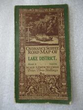 1913 LAKE DISTRICT CUMBRIA Ordnance Survey Cloth Map - Half Inch to 1 Mile - #5
-
$22.99 GBP
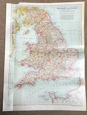 1911 antique color map - england and wales !
-
$79.69 GBP
 rare 1915 map of puerto (porto) rico Coamo-Guayama E.T. HODGE Geodetic chart
-
$2500.00 GBP
 Extremely Rare War Office WW1 Cloth Map of Amiens surrounding areas of France
-
$20.00 GBP
 ww1 Folding Map France Amiens 17 1:100,000 War Office / Ordnance Survey 1916
-
$5.00 GBP
 c1920 Bacon's Cycling & Motoring Map of LIVERPOOL & NORTH WALES - Cloth Map
-
$12.00 GBP
 1911 Linen Back OS Map Cheshire Sheet XXXV S.E. 6" to 1 Mile, Old Withington Etc
-
$20.00 GBP
 France Sheet 51c Edition 1 ww1 Era Map 1:40,000
-
$4.99 GBP
 ANTIQUE 1918 LONG LONDON STREET MAP ROTHERHITHE ACROSS TO SHEPHERDS BUSH
-
$9.95 GBP
 Ordnance Survey Road Map Liverpool, Manchester and Chester 1919
-
$3.50 GBP
 Bacons County Map Gloucester For Cyclists & Tourists c 1910 11
-
$14.99 GBP
 Bartholomew's Survey Map of CHESHIRE (c1910) Sheet 12 England, Folding Cloth Map
-
$2.99 GBP
 ANTIQUE 1918 LONDON STREET MAP STRAND, HOLBORN & BLOOMSBURY REMOVED FROM BOOK
-
$10.00 GBP
 1914 BRISTOL & CARDIFF Ordnance Survey Cloth Map - ½ inch to 1 Mile
-
$11.50 GBP
 OS Ordnance Survey One Inch Cloth Map 30 1911 Colchester
-
$3.75 GBP
 Bacons Cycling Road Map Leamington District c 1910-20 10
-
$30.00 GBP
 Old Folding Map Pisa Italy 1913 8.25" x 6"
-
$261.88 GBP
 1916 Thomas Hewitt Large Folding Antique Map of Southern Tasmania w/ Hobart
-
$25.00 GBP
 Old City Folding Map Milano Milan Italy 1913 9" x 9"
-
$25.00 GBP
 Old City Folding Map Torino Turin Italy 1913 9.5" x 9.5"
-
$14.99 GBP
 Ordnance Survey Map England & Wales Large Sheet Series Sheet 5 South Wales 1913
-
$7.99 GBP
 BELGIUM - 1910 Antique Colour Folding Map
-
$250.00 GBP
 Antique Ordnance Survey Map - The Campo Of Gibraltar - 1912
-
$48.00 GBP
 A Complete Boxed Set of Bartholomew's Quarter Inch Maps of England & Wales c1910
-
$35.00 GBP
 EDINBURGH: Huge Antique map Post Office boundaries history 1917 Leith Portabello
-
$14.99 GBP
 1910 Gall & Inglis / Cary: Easton's Touring & Motoring Map of Peebles & District
-
$24.99 GBP
 1911 antique colour map - india ( northern part )
-
$79.69 GBP
 rare 1915 map of puerto (porto) rico SAN JUAN D.R. SEMMES Geological vol 1 pt 1
-
$5.00 GBP
 1919 OXFORD & HENLEY-On-THAMES Ordnance Survey Contoured Cloth Map #105
-
$4.99 GBP
 ANTIQUE 1918 LONG LONDON STREET MAP HACKNEY MARSH ACROSS TO CRICKLEWOOD
-
$12.50 GBP
 1914 Vintage Ordnance Survey Cloth Map - Guilford & Horsham Surrey
-
$15.99 GBP
 Bartholomew's Revised Half-Inch Map of the English Lakes, Cloth backed, c.1910
-
$34.99 GBP
 Rare Antique THE "COMBINED" MAPS OF LONDON & 25 MILES AROUND - H. Grube
-
$4.99 GBP
 ANTIQUE 1918 LONG LONDON STREET MAP NEW CROSS ACROSS TO THE EAST END
-
$20.00 GBP
 c1910 Philips MAP of LIVERPOOL & DISTRICT N. Wales Manchester CLOTH 74cm x 100cm
-
$4.99 GBP
 ANTIQUE 1918 LONG LONDON STREET MAP VICTORIA PARK ACROSS TO WILLESDEN
-
$350.00 GBP
 Antique Map "Ceylon Survey" (Sri Lanka) R. S. Templeton, 1910
-
$17.99 GBP
 1910 The Courier Map of Dumfriesshire for cyclists, Motorists etc - Bartholomew
-
$15.00 GBP
 1912 Vintage Ordnance Survey White Edition Map CHICHESTER & WORTHING Sussex 136
-
$14.99 GBP
 Antique Ordnance Survey England & Wales Map Sheet 9 -Harrogate, Leeds & Bradford
-
$35.00 GBP
 c1910 Bacon's Map Of South East & Central England 20 Panel Linen Map Pre WW1 VGC
-
$7.99 GBP
 1910 Bartholomew's New Reduced Survey. Sheet 24 Gair Loch & Loch Inver Scotland
-
$19.95 GBP
 1902 - 1914 ANTIQUE ORDNANCE SURVEY MAP - NORTH LONDON - SHEET 29 1/2 INCH CLOTH
-
$12.50 GBP
 Ordnance Survey One Inch Cloth Map 126 Tunbridge Wells Mounted Sections 1914
-
$5.00 GBP
 1912 LONDONDERRY N. Ireland - Ordnance Survey Cloth Map - Sheet #1
-
$20.00 GBP
 Siegen German Empire Original Antique Lithograph Map 1905 Royal Prussian
-
$5.75 GBP
 Vintage Surveyors Map Chart South Middleton Crafting Scrapbooking stage Prop Old
-
$20.00 GBP
 North West Europe Sheet 1 and Part of 4 1:250,000 War Office feb 1915 GSGS 2733
-
$4.99 GBP
 Antique Map Toblach & Cortina D'Ampezzo Italy c 1900 R Lechner Cloth 04
-
$25.00 GBP
 Coblenz German Empire Original Antique Lithograph Map 1900 Royal Prussian
-
$7.99 GBP
 NETHERLANDS HOLLAND Plan - 1910 Antique Folding Map
-
$25.00 GBP
 1910 map of Switzerland. Visperthal. 1:50000. Topographischer. Schweiz Bern
-
$18.00 GBP
 Antique Daily Mail Bird's Eye Map of the British Front 1914-18 WWI
-
$3.99 GBP
 ANTIQUE 1918 LONDON STREET MAP WESTMINSTER & PICCADILLY REMOVED FROM OLD BOOK
-
$5.75 GBP
 Vintage Surveyors Map Chart 1923 Durham Sadberge Burden NER Railway Railwayana
-
$45.00 GBP
 1919 Original Old Folding Muirhead Guide Tube & Tramway Map of London 17" x 13"
-
$12.99 GBP
 Bartholomew's Survey Map of BATH & BRISTOL (c1910) England Sheet 28, Cloth
-
$5.00 GBP
 1912 Cycling Road MAP 50 Miles Around LONDON - VG Cond
-
$28.45 GBP
 The ABC Guide To London - 1917 - Antique British Travel Guide w/Maps Book
-
$3.99 GBP
 ANTIQUE 1918 LONDON STREET MAP THE CITY OF LONDON REMOVED FROM BLUE BOOK
-
$4.99 GBP
 Antique Map Bozen & Fleimsthal Tyrol c 1900 R Lechner Cloth 05
-
$3.99 GBP
 HEREFORD - Old Vintage Bartholomew's New Reduced Survey Half-Inch Map 23
-
$29.99 GBP
 1911 Ordnance Survey Folding Map 6 mile= inch. Stanwell, Harmondsworth, Horton
-
$5.50 GBP
 Bartholomew's Reduced Ordnance Survey Cumberland Map Circa 1918 Dissected Cloth
-
$7.99 GBP
 Vintage Ordnance Survey Map of Barnstable and Exmoor 118 - 1919
-
$4.99 GBP
 1919 Antique Folding Map; Ordnance Survey; Abinger, Wotton, Holmbury. 1"=6 mile
-
$9.95 GBP
 1910 ANTIQUE ORDNANCE SURVEY MAP - BARMOUTH COLOURED EDITION - SHEET 59 1 INCH
-
$10.00 GBP
 1929 WEYMOUTH YEOVIL & TAUNON Ordnance Survey Cloth Map Half Inch to 1 Mile #37
-
$14.99 GBP
 Bartholomew's Road Map of England & Wales (c1910) Middlesex, Essex Suffolk, Sh 9
-
$5.75 GBP
 Antique Surveyors Map Beningbrough Hammerton Vintage Newton Upon Ouse Overton
-
$3.99 GBP
 ANTIQUE 1918 LONDON STREET MAP REGENT ST, OXFORD ST & MARYLEBONE BOOK REMOVED
-
$25.00 GBP
 Fulda German Empire Original Antique Lithograph Map 1911 Royal Prussian
-
$20.00 GBP
 Belgium Ghent 2 Edition 2 Ordnance Survey Map 1916 ww1 Scale 1:100,000
-
$20.00 GBP
 Pfalzburg German Empire Original Antique Lithograph Map 1899 Royal Prussian
-
$20.00 GBP
 Schweinfurt German Empire Original Antique Lithograph Map 1910 Royal Prussian
-
$15.00 GBP
 Trier German Empire Original Antique Lithograph Map 1900 Royal Prussian
-
$20.00 GBP
 Beal. Hunting & Tourists’ Map Of Sussex. c1910. 33” X 18” Stag Hounds Beagles
-
$20.00 GBP
 Würzburg German Empire Original Antique Lithograph Map 1903 Royal Prussian
-
$20.00 GBP
 Marburg German Empire Original Antique Lithograph Map 1911 Royal Prussian
-
$7.99 GBP
 Antique, Ordnance Survey Map of England & Wales by Edward Stanford Ltd, Sheet 39
-
$12.99 GBP
 Weymouth Yeovil Taunton 37 CLOTH Ordnance Survey Map Half Inch 1915 HILL SHADED
-
$8.99 GBP
 BELGIUM ORIGINAL ANTIQUE MAP 1910 EUROPE CARTE
-
$7.99 GBP
 LEIDEN ORIGINAL ANTIQUE MAP 1910 HOLLAND NETHERLANDS TOWN CITY PLAN CARTE
-
$6.99 GBP
 ARNHEM ORIGINAL ANTIQUE MAP 1910 HOLLAND NETHERLANDS TOWN PLAN CARTE
-
$5.75 GBP
 Vintage Surveyors Town Map Plan 1910 High Low Catton York Railway Stage Prop Old
-
$25.00 GBP
 Rothenburg ob der Tauber German Empire Original Antique Lithograph Map 1903
-
$24.99 GBP
 1911 antique colour map - ireland
-
$79.70 GBP
 Road Map of Lee County, Iowa ~ Undated ~ est. early 1900s ~ Condition Acceptable


