 Antiques (UK)
Africa Maps
Asia Maps
Australia/Oceania Maps
Celestial Maps
Central America/Caribbean Maps
Curiosities Maps
Digital Maps
Europe Maps
Map & Globe Mixed Lots
Map & Globe Reproductions
North America Maps
South America Maps
World & Celestial Globes
World Maps

-
$29.00 GBP

 ALASKA, BRITISH COLUMBIA, U.S. WEST COAST, 1877 ADMIRALTY SEA CHART. No. 787
-
$19.99 GBP
 1896 Western Mediterranean Sea Original Antique Map 125 Years Old
-
$320.18 GBP
 Original 1855 Coast Survey Chart North Carolina Albemarle Sound Hand Colored
-
$200.11 GBP
 Original 1851 Coast Survey Chart North Carolina Outer Banks
-
$20.00 GBP
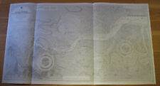 Admiralty Fathom Chart (River Medway - Stangate to Rochester) No 1834
-
$150.00 GBP
 Antique Admiralty Chart 190 - Ports on the Coast of Sicily - 1872 Edition
-
$100.00 GBP
 Antique Admiralty Chart 1762 - Zante Bay - 1864 Edition
-
$250.00 GBP
 Antique Admiralty Chart 250 - Fratelli Rocks to Mehediah - 1867 Edition
-
$175.00 GBP
 Antique Admiralty Chart 1766 - Cape Ferrat to Cape Bougaroni - 1871 Edition
-
$120.00 GBP
 Antique Admiralty Chart 177 - The Faro, or Strait of Messina - 1864 Edition
-
$200.00 GBP
 Antique Admiralty Chart 150 - Port & Roadstead of Marseille - 1877 Edition
-
$150.00 GBP
 Antique Admiralty Chart 252 - Cape Bougaroni to Fratelli Rocks - 1871 Edition
-
$150.00 GBP
 Antique Admiralty Chart 2607 - Marseille to Hyères - 1858 Edition
-
$636.36 GBP
 1891 antique full Set of 14 USA lighthouse district Maps charts nautical
-
$11.48 GBP
 Map Of The World 1884 Thermal Tidal Chart Victorian Lithograph Antique DWP3D
-
$12.01 GBP
 US COAST SURVEY MAP 1854 Washington Smith's Island
-
$175.00 GBP
 Antique Admiralty Chart 1126 - Ports and Anchorages in Corsica - 1874 Edition
-
$150.00 GBP
 Antique Admiralty Chart 181 - Port Augusta - 1868 Edition
-
$120.00 GBP
 Antique Admiralty Chart 1687 - Harbour of Messina, Sicily - 1864 Edition
-
$150.00 GBP
 Antique Admiralty Chart 2608 - France: Hyères to Rade D'Agay - 1858 Edition
-
$125.00 GBP
 Antique Admiralty Chart 153 - Villa Franco Road - 1876 Edition
-
$150.00 GBP
 Antique Admiralty Chart 2609 - France: Rade D'Agay to San Remo - 1858 Edition
-
$150.00 GBP
 Antique Admiralty Chart 1189 - Bonifacio Strait - 1863 Edition
-
$150.00 GBP
 Antique Admiralty Chart 2555 - Leghorn Roadstead - 1883 Edition
-
$150.00 GBP
 Antique Admiralty Chart 158 - Cape Cavallo to Civita Vecchia - 1867 Edition
-
$150.00 GBP
 Antique Admiralty Chart 1195 - Port Barcelona - 1873 Edition
-
$150.00 GBP
 Admiralty Chart 92 - Cape St Vincent to Strait of Gibraltar - 1869 Edition
-
$175.00 GBP
 Antique Admiralty Chart 1719 - Italy West Coast - 1845 Edition
-
$200.00 GBP
 Antique Admiralty Chart 169 - Palermo Bay - 1877 Edition
-
$29.99 GBP
 1863 (1966) Antique Map; Admiralty Chart 262B, Guernsey Eastern Approaches
-
$17.00 GBP
 Vintage Admiralty Sea Chart. No.296. NEWFOUNDLAND, CAPE BONAVISTA 1899 Edition
-
$14.95 GBP
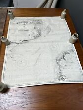
 1870'S ANTIQUE MAP NORTH ATLANTIC AND ITS COASTS UNDERSEA CABLES VIRTUE LONDON
-
$29.99 GBP
 1863 (1965) Antique Map; Admiralty Chart 262C, Guernsey Western Approaches
-
$20.00 GBP
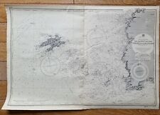
 General Admiralty Chart, River Thames To The Mediterranean Sea. Antique Map
-
$30.00 GBP
 Admiralty Chart 9, Antique Map, River Stour, Harwich To Harkstead - 1911 Edition
-
$239.33 GBP
 Antique French Navigational Sextant Hand Painted Nautical Lithograph Metal Heavy
-
$15.00 GBP
 Vintage Maritime Chart sea map France Channels islands Ushant sailing pic 2694
-
$30.00 GBP
 Admiralty Chart 1607, Antique Map, River Thames Entrance - 1917 Edition
-
$32.01 GBP
 1853 Gunnison Survey Map FOR NEW CHANNEL FROM MILWAUKEE RIVER TO LAKE MICHIGAN
-
$15.97 GBP
 1851 US Coast Survey Map,Point Pinos,Monterey Bay,Califirnia,proposed Lighthouse
-
$40.01 GBP
 Original 1861 Coast Survey Map COQUILLE RIVER Oregon Pacific Ocean Compass Rose
-
$30.00 GBP
 Admiralty Chart 92 - Cape St Vincent to Strait of Gibraltar - 1905 Edition
-
$11.97 GBP
 1851 U S Coast Survey Map,Sandy Hook,NJ,1779-1851,Coves,Lighthouse,changes,Head
-
$30.00 GBP
 Admiralty Chart 1895 , Antique Map, Dover Strait - 1917 Edition
-
$23.97 GBP
 1851 US Coast Survey Map of Mouth of Columbia,California,soundings,other rivers
-
$56.02 GBP
 Original 1863 Coast Survey Chart Map ROCKLAND HARBOR & VICINITY Maine Lighthouse
-
$30.00 GBP
 Admiralty Chart 2451 , Antique Map, Owers To Dungeness - 1912 Edition
-
$9.57 GBP
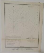 1854 U S Coast Survey Map,Chart, Turtle Harbor, Florida Reefs,Sailing Directions
-
$9.57 GBP
 1854 U S Coast Survey Map,Chart of Coffin's Patches,Florida Reefs, Bottom Depths
-
$40.01 GBP
 Original 1853 Coast Survey Soundings Map HORN ISLAND PASS Pascagoula Mississippi
-
$10.37 GBP
 1851 U S Coast Survey Map,Savannah & 2 Rivers,Approaches,Islands,Soundings,Tides
-
$32.01 GBP
 Original 1853 Coast Survey Soundings Map CORTES BANK California Channel Islands
-
$56.02 GBP
 Original 1863 US Coast Survey Map HALF MOON BAY California Whaling Stations
-
$11.97 GBP
 1851 U S Coast Survey Map E,2,Savannah,River,Islands,survey progress lines,scale
-
$260.15 GBP
 1839 CHART OF NEWARK BAY ~ SURVEY MAP ~ SCARCE ~ LARGE FORMAT
-
$20.00 GBP
 Original 1881 Survey Map MOUTH OF THE COLUMBIA RIVER Oregon Soundings Breakers
-
$15.97 GBP
 1851 U S Coast Survey Map,LI to Cape Henlopen,CT & NJ Coasts,Bays,Sounds,Inlets
-
$28.01 GBP
 Original 1896 Andree Map ATLANTIC OCEAN STEAMSHIP ROUTES With Travel Times
-
$120.06 GBP
 Original John Maffitt 1852 Coast Survey Map NEW RIVER INLET & BAR North Carolina
-
$28.01 GBP
 1887 Antique Nautical Sea Sailing Chart Map Martinique Carribbean (1916)
-
$56.02 GBP
 Original 1853 Coast Survey Map PUNGOTEAGUE CREEK Chesapeake Bay Virginia Wharf
-
$63.24 GBP
 GENUINE ANTIQUE 1893 color lithographed map CAPE CHARLES VIRGINIA VA
-
$12.00 GBP
 Original 1882 Barlow Survey Map BRIDGEPORT HARBOR Connecticut Lighthouse Beacons
-
$120.07 GBP
 Bristol Harbor R.I. 1864 Coast Survey Antique Map Topography and Navigation
-
$103.26 GBP
 SALE! GENUINE ANTIQUE 1893 color lithographed map East End LONG ISLAND NEW YORK
-
$64.04 GBP
 NEW CALEDONIA BAYE DE UGUE 1876 ANTIQUE SEA CHART IN COLORS 19TH CENTURY
-
$47.23 GBP
 GENUINE ANTIQUE 1893 color lithographed map LAGOON HARBOR CAPE CANAVERAL FLORIDA
-
$87.25 GBP
 GENUINE ANTIQUE 1893 color lithographed map PROVINCETOWN HARBOR MASSACHUSETTS MA
-
$76.04 GBP
 GENUINE ANTIQUE 1893 color lithographed map MOUTH OF THE MISSISSIPPI RIVER
-
$60.03 GBP
 1897 Guadalupe island California US coast survey antique map white sharks
-
$43.98 GBP
 1863 US Coast Survey Cape Florida to Tortuga Islands Map Chart
-
$36.02 GBP
 GENUINE ANTIQUE 1893 color LITHOGRAPHIC map of part of MAINE coast YARMOUTH
-
$31.22 GBP
 GENUINE ANTIQUE 1893 color lithographed map MARQUESAS KEYS FLORIDA
-
$127.27 GBP
 GENUINE ANTIQUE 1893 color lithographed map SAVANNAH DISTRICT HILTON HEAD SC
-
$108.06 GBP
 GENUINE ANTIQUE 1893 color lithographed map North CAROLINA HARBORS cape Fear


