 Antiques (UK)
-
$24.07 GBP

 TOPOGRAPHICAL MAP OF THE ROAD FROM MISSOURI TO OREGON Reprint of 1846 - 25x16
-
$60.19 GBP
 TOPOGRAPHICAL MAP OF THE ROAD FROM MISSOURI TO OREGON Mid-20thc Reprint of 1846
-
$12.00 GBP
 Vintage Reproduction 1778 – 1780 West Point Map
-
$24.07 GBP
 Michael D. Heaston Catalog with Map – Lot of 3 - Texas - N. America - Mexico
-
$24.07 GBP
 Topographical Map of the City of Cincinnati From Actual Survey by H.L. Barnum
-
$8.02 GBP
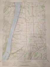 Keuka Park NY Topographic Map 22" x 27" 1942
-
$4.00 GBP
 Vintage 1893 Reprinted 1942 Topographical Map of Brookfield Sturbridge Mass
-
$13.60 GBP
 Vintage 1942 Flat Wall Topography Map Orville Ca. The Army Corps Of Engineers
-
$52.16 GBP
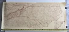 U.S. Coast Survey 1865 North Carolina W.P. Cumming Map Print 17 1/2 x 38
-
$401.24 GBP
 1795 Bowles’ Map of the United States of America: Lewis & Clark Explorer Map Ltd
-
$2.01 GBP
 GLACIER BAY MAP
-
$4.01 GBP
 Map Of Voyages Of Samuel De Champlain
-
$24.03 GBP
 Vintage 1960's Reproduction 1735 North America Territory Map by Seutter
-
$24.03 GBP
 Vintage 1960's Reproduction 17th Century North South America Colorized Wall Map
-
$24.03 GBP
 Vintage 1960's Reproduction 17th Century Global Colorized Wall Map by N Visscher


