 Antiques (UK)
-
$39.84 GBP

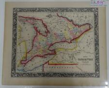 S. Augustus Mitchell Hand Colored 1860 Canada West Counties Great Lakes Map B14
-
$23.83 GBP
 1946 NEW YORK STATE Cultural Thematic Map Chromo Litography C13-2
-
$27.09 GBP
 Ohio - Michigan Wauseon Quadrangle (1911 survey) Original Vintage USGS Topo Map
-
$33.87 GBP
 OHIO -MICHIGAN SWANTON QUAD ORIGINAL 1927 USGS QUADRANGLE 17X21 MAP EXCELLENT...
-
$19.92 GBP
 1907 Pomeroy Ohio & Surrounding Area USGS Topographic Survey 17"x 21" Color Map
-
$9.56 GBP
 Vintage 1928 Elyria Oh. Zoning Map Street Council Officials Signed Amendments
-
$19.92 GBP
 1909 Newark Ohio & Surrounding Area USGS Topographic Survey 17"x 21" Color Map
-
$11.96 GBP
 Vintage 1940’s Pictorial Map Parma Ohio City School District Lakes Roads MORE
-
$15.94 GBP
 Original Vintage Map of the Baltimore & Ohio Railroad System ~ 1910
-
$11.96 GBP
 Antique USGS Topographic Map Flushing Ohio Printed 1922 16x20 Art
-
$15.94 GBP
 Original Vintage Map of the Carolina, Clinchfield & Ohio Railway ~ 1915
-
$23.11 GBP
 2003 Vintage COLOR Map of WASHINGTON TOWNSHIP Montgomery County, Ohio - OH Map
-
$11.96 GBP
 Napoleon Ohio Antique USGS Topographic Map Printed 1930 16x20 Art
-
$15.94 GBP
 Original Vintage Map of the Chesapeake & Ohio Railway Lines 1915
-
$23.83 GBP
 1946 OHIO STATE Cultural Thematic Map Chromo Litography C13-2
-
$15.94 GBP
 Original Vintage Map of the Baltimore & Ohio System, 1926
-
$7.13 GBP
 Vintage USGS topo map Berea OH 1963
-
$7.13 GBP
 Vintage USGS topo map New Pittsburgh OH 1961
-
$7.13 GBP
 Vintage USGS topo map Broadview Heights OH 1963
-
$9.56 GBP
 Map War Secession West Operations 1871 Victorian Woodcut Print History DWAA12
-
$59.78 GBP
 Framed Map Print - Buckeye Lake Ohio
-
$23.51 GBP
 Oberlin Ohio 1969 Original Vintage U.S. Geologic Survey Map 26.75x21.25 State OH
-
$19.92 GBP
 1915 Millersburg Ohio & Area USGS Topographic Survey 16"x 20" Color Map
-
$12.75 GBP
 Map War Of 1812 Indian Wars 1871 Victorian Lithograph History Swinton DWAA12
-
$15.90 GBP
 Vintage Site Survey Akron Elma St Hillier Ave Payne Engineering c.1900s F214
-
$19.92 GBP
 1912 Loudonville Ohio & Area USGS Topographic Survey 17"x 21" Color Map
-
$19.92 GBP
 1912 Caldwell Ohio & Surrounding Area USGS Topographic Survey 16"x 20" Color Map
-
$19.92 GBP
 1914 Navarre Ohio & Surrounding Area USGS Topographic Survey 17"x 21" Color Map
-
$15.94 GBP
 Original Vintage Map of the Carolina, Clinchfield and Ohio Railway 1915
-
$15.94 GBP
 Original Vintage Map of the Chesapeake & Ohio Railway System - 1910
-
$15.94 GBP
 Original Vintage Map of the Chesapeake & Ohio Railway Lines, 1926
-
$15.94 GBP
 Original Vintage Map of the Chesapeake & Ohio Railway System ~ 1910
-
$19.92 GBP
 1905 Athens Ohio & Surrounding Area USGS Topographic Survey 17"x 21" Color Map
-
$19.92 GBP
 1910 Philo Ohio & Surrounding Area USGS Topographic Survey 17"x 21" Color Map
-
$19.92 GBP
 1914 Gambier Ohio & Surrounding Area USGS Topographic Survey 16"x 20" Color Map
-
$19.92 GBP
 1910 McConnelsville Ohio Area USGS Topographic Survey 17"x 21" Color Map
-
$19.92 GBP
 1911 New Lexington Ohio Area USGS Topographic Survey 17"x 21" Color Map
-
$15.94 GBP
 Original Vintage Map of the Carolina, Clinchfield & Ohio Railway ~ 1910
-
$15.94 GBP
 Original Vintage Map of the Chesapeake & Ohio Railway Lines ~ 1915
-
$15.94 GBP
 Original Vintage Map of the Chesapeake & Ohio Railway Lines 1917
-
$15.94 GBP
 Original Vintage Map of the Carolina, Clinchfield & Ohio Railway ~ 1910
-
$15.94 GBP
 Original Vintage Map of the Carolina, Clinchfield & Ohio Railway ~ 1910
-
$15.94 GBP
 Original Vintage Map of the Chesapeake & Ohio Railway System ~ 1910
-
$19.92 GBP
 1940's Army (like USGS) topo map West Columbus Ohio -Sheet 4363 I
-
$19.92 GBP
 1912 Dover Ohio & Surrounding Area USGS Topographic Survey 17"x 21" Color Map
-
$15.10 GBP
 Vintage 1947 State Map Print Suitable For Framing 2 Sided Oklahoma Ohio
-
$43.83 GBP
 USGS 15' Jackson, OH topographic map Oct 1913 edition
-
$27.90 GBP
 Vintage Map US Army Corps Engineers Columbus, Ohio,1950
-
$27.90 GBP
 Vintage Map US Army Corps Engineers Marion Ohio, 1950
-
$35.86 GBP
 USGS 15' Ironton, Ohio/West Virginia topographic map 1900 edition.
-
$31.87 GBP
 USGS 15' Topographic Map Wheeling, WV/Ohio/Pennsylvania 1942 edition.
-
$23.91 GBP
 Conneaut Harbor, Ohio 1896
-
$31.80 GBP
 1909 Antique Color Map Auglaize County Ohio New Bremen Fryburg 34 X 25 #0381
-
$11.88 GBP
 Antique 1906 Color Map Ohio 11" X 16" #4133
-
$39.84 GBP
 Ohio North America Map 1935 United States 14 x 11" Midwest LGAD99
-
$31.80 GBP
 1902 Antique Map Ohio Columbus Galloway Harrisburg Groveport 30 X 21" #8784
-
$31.80 GBP
 1906 Antique Map Meigs County Ohio Rushville Racine Reedsville 35.5 X 25" #8558
-
$23.91 GBP
 Outline Map Fairfield Ohio Vintage Topographic - Unknown Year
-
$31.88 GBP
 1890 US Coast & Geodetic Survey Map #5 Between Atlantic Coast & Ohio River.
-
$20.71 GBP
 CIRCLEVILLE OHIO ORIGINAL 1961 USGS QUADRANGLE 27X22 MAP EXCELLENT CONDITION
-
$31.87 GBP
 USGS 15' Cambridge, OH topographic map 1912 edition
-
$23.90 GBP
 CANAL WINCHESTER OHIO ORIGINAL 1966 USGS QUADRANGLE 27X22 MAP EXCELLENT COND.
-
$23.91 GBP
 Ashtabula Harbor, Ohio, 1896
-
$31.88 GBP
 Ohio River, Rising Sun Bar, Survey of 1886
-
$27.90 GBP
 Ohio River, Rising Sun Bar, Survey of 1871
-
$23.90 GBP
 LOGAN OHIO ORIGINAL 1961 USGS QUADRANGLE 27X22 MAP EXCELLENT CONDITION
-
$23.90 GBP
 EAST RINGGOLD OHIO ORIGINAL 1958 USGS QUADRANGLE 27X22 MAP EXCELLENT CONDITION
-
$23.90 GBP
 JUNCTION CITY OHIO ORIGINAL 1961 USGS QUADRANGLE 27X22 MAP EXCELLENT CONDITION
-
$31.88 GBP
 1890 US Coast & Geodetic Survey Map # 6 Between Ohio & Mississippi Rivers


