 Antiques (UK)
-
$11.33 GBP

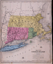
 1903 Rhode Island & Connecticut state map. United States. New England.
-
$63.75 GBP
 1879 Map New England USA Victorian Atlas Harpers Geography 1st Edition DWAA9
-
$47.81 GBP
 Map Oxford Massachusetts CT RI USGS 1979 Topographic Geo 1:24000 27x22" TOPO12
-
$60.97 GBP
 Burriville Providence County Rhode Island telegraphs phones 1895 huge scarce map
-
$5.00 GBP
 c1895 state map of Rhode Island antique vintage Britannica 9th
-
$13.55 GBP
 Connecticut & Rhode Island - Original 1902 Map by The Century Company, Antique
-
$10.36 GBP
 1943 Vintage Map - New York to Newport 1776-1783 - Rhode Island - New York City
-
$14.35 GBP
 Massachusetts, Connecticut & Rhode Island - Original 1882 Map by Phillips & Hunt
-
$39.44 GBP
 1878 NICE ORIGINAL MAP CANADA MONTREAL TORONTO GREAT LAKES ALASKA GREENLAND
-
$10.32 GBP
 1911 Antique Rand McNally Map of CONNECTICUT & RHODE ISLAND & State Demographics
-
$19.85 GBP
 1885 East Coast UNITED STATES Vintage MAP New York Maine ORIG 11.5 x 9.5 C17-3
-
$19.85 GBP
 1878 Eastern UNITED STATES Vintage MAP New York Maine NJ ORIG 11.5 x 9.5 C17-3
-
$15.94 GBP
 Connecticut & Rhode Island - Original 1902 Map by The Century Co. RI Antique
-
$41.83 GBP
 Map Oxford Massachusetts CT RI USGS 1979 Topographic Geo 1:24000 27x22" 2 TOPO12
-
$27.90 GBP
 Antique County Map of Massachusetts, Connecticut & Rhode Island, 1880, 23"x15"
-
$16.14 GBP
 Map Uxbridge Massachusetts RI USGS 1979 Topographic Geo 1:24000 27x22" TOPO12
-
$17.14 GBP
 1889 Map ~ BOSTON - MASSACHUSETTS - RHODE ISLAND ~ (XL17x23) Free S&H -#001
-
$14.31 GBP
 Vintage RHODE ISLAND Map Wall Art Decor Providence Newport Warwick DATED 1914
-
$21.64 GBP
 1854 Map LONG ISLAND, CONNECTICUT, MASACHUSETTS, RI ~ Hand Colored (9x11)-#010
-
$7.86 GBP
 1888 Color County Map 5 New England States see title page picture
-
$23.91 GBP
 1899 United States - 1902 Massachusetts / Rhode Island / Connecticut Atlas Maps
-
$9.52 GBP
 Vintage RHODE ISLAND Map Wall Art Decor 1940s Original Antique Providence
-
$35.87 GBP
 Original 1882 Antique Map MASSACHUSETTS CONNECTICUT RHODE ISLAND Boston Stamford
-
$7.96 GBP
 Map Rhode Island USAGenuine Dated 1891 Town, County, Railroads, Area, Population
-
$9.32 GBP
 1943 Vintage Map - The United States on March 4, 1861 - The Civil War
-
$9.32 GBP
 1943 Vintage Map - The Thirteen Colonies - New York City Boston Charleston
-
$14.35 GBP
 Massachusetts, Connecticut & Rhode Island - Original 1891 Map by Hunt & Eaton
-
$15.90 GBP
 CENTURY ATLAS MAP PLATE #10 CONNECTICUT RHODE ISLAND NEWPORT RI USA 1911 ANTIQUE
-
$31.87 GBP
 1879 Map Rhode Island United States Victorian Geography 1st Edition DWAA9
-
$35.86 GBP
 Map Oxford Massachusetts CT RI USGS 1979 Topographic Geo 1:24000 27x22" 3 TOPO12
-
$60.56 GBP
 1873 Mitchell's Map of Massachusetts, CT, R.I., Authentic Hand-Colored Antique
-
$35.86 GBP
 Map Blackstone Massachusetts RI USGS 1979 Topographic Geo 1:24000 27x22" TOPO12
-
$7.96 GBP
 CRAM'S ATLAS MAP PAGE STATE OF CONNECTICUT & RHODE ISLAND 1899 VINTAGE
-
$59.78 GBP
 New York NH VT CT MA RI 1860 hand-color Mitchell antique map 23.5" x 15.2"
-
$18.29 GBP
 Vintage Southern New England Map Massachusetts Rhode Island Connecticut ca 1887
-
$14.35 GBP
 Authentic 1900 Map ~ THE COAST of NEW ENGLAND ~ Settlements in the New Colonies
-
$59.78 GBP
 1862 Johnson Massachusetts Rhode Island CT antique map 26" x 17.8" nice color
-
$31.88 GBP
 Authentic 1900 Large, Detailed Color Map ~ US America Eastern State East ~ Rare
-
$23.90 GBP
 Map Webster Mass CT RI Geological Topographic Survey 1982 24 x 38" DWX6A
-
$11.95 GBP
 OLD ANTIQUE 1908 MASS. & RI / VERMONT & NH MAP COLOR CHROMOLITHOGRAPH PRINT
-
$11.05 GBP
 1903 State Map of Massachusetts Rhode Island Connecticut Detailed 21.5" x 13.5
-
$11.95 GBP
 Original 1905 Map MASSACHUSETTS CONNECTICUT RHODE ISLAND Nantucket Railroad
-
$7.96 GBP
 CRAM'S ATLAS MAP PAGE MASSACHUSETTS RHODE ISLAND VERMON NH 1899 VINTAGE
-
$38.26 GBP
 1918 Map of PROVIDENCE Rhode Island w/ Chalkstone Pleasant Valley & Smith Street
-
$33.47 GBP
Original 1885 Antique Map MASSACHUSETTS CONNECTICUT RHODE ISLAND Lowell Hartford
-
$15.93 GBP
 Original 1897 Map CONNECTICUT RHODE ISLAND Newport New Haven Hartford Providence
-
$16.48 GBP
 1887 Map MASSACHUSETTS, CONNECTICUT RI ~ Authentic Mitchell / BRADLEY Map #034
-
$314.82 GBP
 Frank A Gray / J.M. Atwood 1880 Map of Massachusetts, Rhode Island & Connecticut
-
$24.64 GBP
 Old 1897 Map ~ CONNECTICUT - RHODE ISLAND ~ Authentic Atlas Map (LG15x22) -#058
-
$11.05 GBP
 1939 State Map of Rhode Island and South Carolina Bright Colors Highly Detailed
-
$47.82 GBP
 Authentic 1900 Large Detailed Color Map ~ TERRITORIAL GROWTH of U.S. Very Scarce
-
$17.93 GBP
 Rhode Island North America Map 1935 United States 14 x 11" New England LGAD99
-
$14.35 GBP
 Map Mass RI CT Index Chart Geological Topographic Survey 1984 51 x 32" DWX6A
-
$7.96 GBP
 Original 1888 Map MASSACHUSETTS RHODE ISLAND Newport Providence Worcester Revere
-
$71.72 GBP
 Original Hand Colored 1863 Johnson Map MASSACHUSETTS CONNECTICUT RHODE ISLAND
-
$63.76 GBP
 Huge Authentic Original Map ~ 1920 NEW ENGLAND ~ MAIN AUTOMOBILE ROUTES 26 x 19
-
$8.26 GBP
 Massachusetts Rhode Island Antique Map 1901 Massachusetts RI Cram's 14½" x 22"
-
$28.69 GBP
 Large Original 1898 Antique Map RHODE ISLAND Pawtucket Warwick Cranston Newport
-
$9.96 GBP
 Connecticut Massachusetts Rhode Island New England AAA 1987 Travel Guide Map
-
$6.77 GBP
 CONNECTICUT & RHODE ISLAND ATLAS MAP PAGE PLATE 1908 VINTAGE GEORGE F. CRAM
-
$7.96 GBP
 c 1925 Hammond County Map - Massachusetts & Rhode Island - Boston Providence
-
$10.32 GBP
 Rhode Island Antique Vintage Pictorial Map (Small/Postcard size)
-
$36.62 GBP
 1877 Map MASSACHUSETTS, CONNECTICUT, RHODE ISLAND ~ Authentic Mitchell Map -#039
-
$31.87 GBP
 Original 1883 Map RHODE ISLAND Pawtucket Warren Newport Railroads Lighthouses
-
$11.96 GBP
 ORIGINAL 1883 Cram Atlas Map MA, CT, RI, NH, VT 5 States Hand Colored
-
$6.77 GBP
 MASSACHUSETTS & RHODE ISLAND ATLAS MAP PAGE PLATE 1908 VINTAGE GEORGE F. CRAM
-
$119.55 GBP
 Bristol Harbor R.I. 1864 Coast Survey Antique Map Topography and Navigation
-
$15.94 GBP
 East Greenwich Rhode Island 1975 Vintage Lithograph Topographic Map - unused
-
$39.81 GBP
 1863 US Coast Survey Atlantic Coast Cape Sable to Sandy Hook Map Chart


