 Antiques (UK)
-
$59.78 GBP

 RARE Early 1871 Antique Map of Massachusetts, Schouler, CIVIL WAR, Williams
-
$19.13 GBP
 ANTIQUE 1890 MAINE MAP MEASURES 18 1/2" BY 12"
-
$78.90 GBP
 3' x 4' 1924 Soil Survey Map Middlesex County MA Boston Gorgeous Color Very Rare
-
$25.50 GBP
 1879 Map Massachusetts Boston US Victorian Atlas Geography 1st Edition DWAA9
-
$49.00 GBP
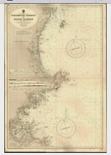 VINTAGE ADMIRALTY CHART. No.1227. PORTSMOUTH HARBOUR - BOSTON HARBOUR. 1960 Edn.
-
$49.00 GBP
 ANTIQUE ADMIRALTY CHART. No. 1227. APPROACHES to BOSTON BAY. 1899.
-
$15.00 GBP
 Copy of Antique Map of Boston, Massachusetts 1769 Dedicated to Jonathan Belcher
-
$290.00 GBP
 Antique Map "Boston" (U.S.A.) John Tallis, 1851
-
$99.99 GBP
 1812 COLOUR MAP OF THE WORLD ON MERCATORS PROJECTION WESTERN PART BY NEELE *
-
$89.99 GBP
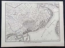
 1925 Indexed Antique Map of Boston, Massachusetts by Walker Lithograph Co.
-
$18.99 GBP
 Boston, USA in 1842 SDUK town plan old map repro
-
$39.95 GBP
 North East United States New York Boston Harbour Hampton Roads George Philip Map
-
$1434.61 GBP
 Antique Novi Belgii quod nunc Novi Jorck vocatur Novae Angliae partis Virginiae
-
$15.94 GBP
 Original Vintage Map of the Boston & Northern & Old Colony Street RR Co - 1910
-
$15.94 GBP
 Original Vintage Map of the Boston & Northern & Old Colony St. RR Co. - 1910
-
$15.94 GBP
 Original Vintage Map of the Boston Elevated Railway Co. System ~ 1910
-
$158.00 GBP
 1887 LARGE VICTORIAN MAP ~ UNITED STATES AMERICA EASTERN BOSTON PHILADELPHIA etc
-
$14.35 GBP
 Vintage Boston, Mass., USGS Topographic Map, 1/62,500, 1903
-
$22.71 GBP
 Vintage Color Map ~ New England ~ RI CONN MASS NH VERMONT MAINE Printed 1883
-
$99.63 GBP
 Scarce Vintage Illustrated History Map ~ Old Shawmut Boston to Modern
-
$14.35 GBP
 Authentic 1900 Map ~ BOSTON with its Environs in 1775-1776 ~ Original Detailed
-
$79.69 GBP
 Rare 1975 Humorous Map 24x18 A Bostonian's View of the United States of America
-
$35.86 GBP
 c 1910 Walkers Automobile Map The North Shore Massachusetts Railroads Boston
-
$71.72 GBP
 1885 Large Color Print of Map of Boston, Nicely Matted
-
$119.55 GBP
 Antique Original Huge Colorful USGS 1956 Boston and Vicinity Map
-
$15.94 GBP
 Original Vintage Map of the Boston & Northern & Old Colony ~ 1910
-
$29.24 GBP
 1872 Illustrated London News Antique Map of Boston after The Great Fire of 1872
-
$7.17 GBP
 Topographic Map Dept interior Boston North 1986 Melrose Somerville Waltham more
-
$15.94 GBP
 Original Vintage Map of the Boston Elevated Railway Co. System - 1910
-
$43.84 GBP
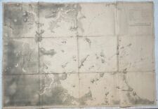
 Map of The Country Northwest of Boston 1896 ORIGINAL by The Appalachian Club
-
$474.22 GBP
 Antique 1870 Des Barres 'BOSTON HARBOR' Revolutionary War MAP Meisel LITHOGRAPH
-
$43.83 GBP
 1947 Norwood, Massachusetts - USGS Topographic Map - Boston, Dedham, Westwood
-
$23.90 GBP
 1940's Army topographic map Boston South Massachusetts -Sheet 6768 I SE
-
$179.33 GBP
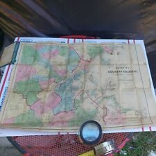 RARE A.Williams & Co. 1872 Map of Boston & Country Adjacent HAND COLORED 28"X20"
-
$39.84 GBP
 1940's Army topographic map Boston North Massachusetts -Sheet 6768 I NE
-
$79.69 GBP
 1946 Boston Harbor Map - Hull, Massachusetts - USGS Topographic, Norfolk Hingham
-
$75.72 GBP
 1910 Reprint Of 1903 BOSTON Massachusetts TOPO Multicolored USGS Survey
-
$23.91 GBP
 Boston Harbor Massachusetts, Showing Proposed Improvements 1888
-
$43.84 GBP
 Boston Harbor, Massachusetts, 1888
-
$23.90 GBP
 STATES OF MASSACHUSETTS RHODE ISLAND CONNECTICUT ORIGINAL 1950 USGS 30x23 MAP
-
$70.14 GBP
 1975 Boston Redevelopment Authority General Land Use Map 36" X 42" Poster


