 Antiques (UK)
-
$34.99 GBP

 The Uniquefold Map of London vintage collectable map, by Kerry Lee c. 1955
-
$20.00 GBP
 1950 Vintage Folding Guide Map Ipswich Suffolk England 10.5" x 8"
-
$355.60 GBP
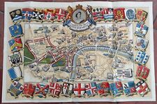 1953 Historic Queen Elizabeth II Royal Coronation Route Map London Pictorial
-
$20.00 GBP
 1950 Vintage Folding Guide Map Clacton on Sea Essex England 11.5" x 6.5"
-
$6.50 GBP
 Manchester Map Ordnance Survey. 1953. No. 101.
-
$5.00 GBP
 Barnett's Havering Map - Street Map and Fold-Out Map 1950s - Romford Hornchurch+
-
$9.88 GBP
 VINTAGE MAP OF ROME 50s Nuovissima Pianta Mapa Roma Italia RARE Enrico Verdesi
-
$7.99 GBP
 c.1950 Bartholomew Half-Inch Map Collection x 8
-
$6.00 GBP
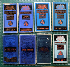
 Bartholomew's Revised 'Half-inch' Contoured Map - on cloth, Dorset, circa 1953.
-
$14.00 GBP
 Devon & Cornwall Vintage Maps & Guides Inc. 1950 Bartholomews Exmoor & Dartmoor
-
$4.99 GBP
 OLD LARGE 38" x 30" NATIONAL GEOGRAPHIC MAP 1950? very good condition
-
$5.75 GBP
 Vintage AA Map of France, Belgium, Switzerland & Adjoining Territories Folding
-
$5.00 GBP
 c1950 OLIVER'S ROAD GUIDE and MAP For MOTORISTS Routes & Distance From LIVERPOOL
-
$43.84 GBP
 Official Road Map For Allied Forces Europe France Edition 1 AMS M305 1953
-
$15.00 GBP
 Set of 9 Vintage Bartholomew's revised half inch contoured maps
-
$15.00 GBP
 1950 Vintage Folding Guide Map Colchester Essex England 8.5" x 6.5"
-
$12.50 GBP
 1951 Galway & Mayo Ireland Bartholomew's Map Quarter Inch to Mile
-
$7.99 GBP
 Dolgelley Vintage Map North West Wales Dated 1953 Ordnance Survey 116 Large Maps
-
$149.97 GBP
 Esso Pictorial Map Of Denmark C.Bering Politikens Forlag Printed 1950s
-
$5.00 GBP
 c1950 OLIVER'S ROAD GUIDE and MAP For MOTORISTS Routes & Distance From LIVERPOOL
-
$7.99 GBP
 1952 HISTORICAL MAP SCOTLAND DEPICTING ARMS OF SCOTTISH FAMILY CLANS AND YEARS.
-
$15.00 GBP
 Ordnance Survey Cheshire Cloth Map Sheet SJ 47 Property of BMNH 1952
-
$48.50 GBP
 PICTORIAL MAP OF ESSEX c.1950, MINT CONDITION, by WAYFARER MAPS , WESTON, HERTS.
-
$24.99 GBP
 WORLD REFUGEE YEAR 1959-60 MAP by John Bartholomew, never bound in or used.
-
$12.50 GBP
 1951 Galway & Mayo Ireland Bartholomew's Map Quarter Inch to Mile
-
$4.49 GBP
![1950s Ordnance Survey Cloth Map Snowdon, 1 Inch to mile **[25978]](https://i.ebayimg.com/thumbs/images/g/-KMAAOSwEkljU-xS/s-l225.jpg) 1950s Ordnance Survey Cloth Map Snowdon, 1 Inch to mile **[25978]
1950s Ordnance Survey Cloth Map Snowdon, 1 Inch to mile **[25978]
-
$24.99 GBP
 Vintage Aberdeen Town Plan by Bartholomew (1958) Folding Map, Scotland, Scottish
-
$4.50 GBP
 Lancaster & Kendal ‘Seventh Series’ One Inch Ordnance Survey Map 1957 Sheet 89
-
$19.92 GBP
 Rare vintage imported 1958 Mobil Highway Map of Italy, Italia, Mobil Oil, Travel
-
$13.68 GBP
 Map of Great Britain Southern Section 1951 Automobile Association
-
$9.99 GBP
 Bukta Campsite Map Of Great Britain 1959 With Adds For Camping Kits. Rare Gift
-
$26.32 GBP
 Original MAP: THUN SWITZERLAND 1936,
-
$4.50 GBP
 Hereford ‘Seventh Series’ One Inch Ordnance Survey Map 1952 Sheet 142
-
$14.00 GBP
 5 X Vintage Dunlop UK Maps. 3 Large Folding Paper Maps & 2 Motorway Map Books.
-
$11.96 GBP
 Post WAR VTG 1950's JAPANESE/English~Bilingual 'MAP OF TOKYO'~29 1/2" x 40 1/2"~
-
$11.50 GBP
 Vintage Europe Road Atlas. Fold Out Maps Kummerly & Frey
-
$14.00 GBP
 Vintage Historical Map of Scotland By L.G Bullock John Bartholomew & Sons LTD
-
$7.99 GBP
 Vintage Map Bala And Welshpool 1953 Large Map Ordnance Survey 117 Fold out
-
$3.98 GBP
 VINTAGE NEDERLAND PAYS-BAS FALK PLAN ROADMAP Auto Travel TOURIST FOLDING MAP
-
$12.80 GBP
 bartholomews vintage map See Photos
-
$3.00 GBP
 National Grid Paper Ordnance Survey Map No 65 Kintyre (1955)
-
$7.95 GBP
 North Wales Vintage Bartholomew's Map, Revised Half-Inch Contoured, Sheet 27
-
$4.50 GBP
 Keswick ‘Seventh Series’ One Inch Ordnance Survey Map 1958 Sheet 82
-
$8.00 GBP
 Vintage Ward Lock's Oban Skye Fort William - Maps Plans Illustrations
-
$19.99 GBP
 Vintage map Mountain Huts of the Eastern Alps D.A.V & O.A.V 1957
-
$9.99 GBP
 1952 Accident Prevention Traffic Map Chatham Gillingham Kent Road Safety SCARCE
-
$4.49 GBP
 Bartholomew colour contoured half inch map of mid Wales 22 - 1958
-
$4.00 GBP
 1950s Bartholomew's SURREY Half-Inch Sheet 9 Vintage Cloth Map
-
$15.00 GBP
 Ordnance Survey Westmorland First Series Cloth Map Sheet 35/42 Property of BMNH
-
$1.00 GBP
 Vintage Michelin map No. 90 for Corse ( Corcisca ) Dated 1949
-
$18.00 GBP
 1952 Vintage Historical Map of Scotland by L G Bullock - Cloth Folding 26" x 38"
-
$25.00 GBP
 1951 Vintage Folding Map Hampshire & Dorset John Bartholomew 10" x 6.5"
-
$20.00 GBP
 Job Lot Of 1950s Vintage WALES Road Maps, Guides & A Welsh Counties Penant Flag.
-
$8.00 GBP
 Vintage Bartholomews Half-Inch Map - Cardigan - 1954
-
$8.00 GBP
 Vintage Bartholomews Half-Inch Map - MId-Wales - 1955
-
$9.99 GBP
 Collection of Five Cloth Ordnance Survey Maps, Sheets 29, 93, 99, 102 & 104
-
$15.00 GBP
 Ordnance Survey Cumberland Cloth Map Sheet 35/32 Property of BMNH 1953
-
$17.99 GBP
 Vintage Ordnance Survey Map of North Wales and Manchester c1952 - O/S Sheet 4
-
$4.50 GBP
 Vintage Map Der Grunewald Berlin 1952 Laminated And Folded
-
$12.50 GBP
 1950 Cork & Killarney Ireland Bartholomew's Map Quarter Inch to Mile
-
$15.00 GBP
 Ordnance Survey Cumberland Cloth Map Sheet 35/34 Property of BMNH 1950
-
$9.99 GBP
 1951 Bartholomew's Revised 1/4 inch Map of Ireland. Sht 2 Dublin and Roscommon
-
$35.00 GBP
 1952 SURVEY OF CYPRUS ADMINISTRATION MAP
-
$5.00 GBP
 1951 Bartholomew's ESSEX - Half-Inch Sheet 16 Vintage Cloth Map
-
$7.97 GBP
 Ordnance Survey paper Map of Ireland Killarney District 1 Inch to 1 mile c1953
-
$4.00 GBP
 Official Road Map For Allied Forces Europe NE France Edition 1 AMS M406 1955
-
$4.50 GBP
 Banbury ‘Seventh Series’ One Inch Ordnance Survey Map 1953 Sheet 145
-
$12.00 GBP
 Vintage Map of the Gower Peninsular - approved by the Gower Society
-
$4.95 GBP
 SLIGO VINTAGE 1950s ORDNANCE SURVEY MAP OF IRELAND SHEET 7
-
$7.50 GBP
 HAYES & DISTRICT West London Middlesex FOX'S CLOTH MAP & Street Plan - PRISTINE
-
$15.00 GBP
 Ordnance Survey Dumfries First Series Cloth Map Sheet 35/27 Property of BMNH
-
$4.50 GBP
 Bristol & Newport ‘Seventh Series’ One Inch Ordnance Survey Map 1953 Sheet 155
-
$15.00 GBP
 1952 Vintage Historical Map of Scotland by L G Bullock - Cloth Folding 26" x 38"
-
$3.99 GBP
 Johnson's Motoring And Touring Map Of Scotland
-
$5.75 GBP
 Vintage Mono Ordnance Survey Map Chart 1958 Aislaby Cropton Wrelton Middleton
-
$2.99 GBP
 Vintage OS Map BANBURY Published War Office 1954 4620
-
$7.50 GBP
 1950 Ordnance Survey Map of the ISLE OF MAN Vintage Cloth Map - War revision
-
$5.75 GBP
 Vintage Black White Ordnance Survey Map Chart 1958 Kirkbymoorside Nawton Skiplam
-
$5.00 GBP
 Bartholomew's NEW FOREST Half-Inch Sheet 5 - 1950 Vintage Cloth Map
-
$5.75 GBP
 Vintage Black White Ordnance Survey Map Chart 1958 Appleton Le Moors Sinnington
-
$19.99 GBP
 Vintage Fold out urban City Map of Oslo 1951 NORWAY **RARE**
-
$4.95 GBP
 GALWAY BAY VINTAGE 1970s ORDNANCE SURVEY MAP OF IRELAND SHEET 14
-
$7.95 GBP
 Wharfdale Vintage Bartholomew's Map, Revised Half-Inch Contoured, Sheet 32
-
$15.00 GBP
 Ordnance Survey Dumfriesshire Cloth Map Sheet NY 17 Property of BMNH 1954
-
$4.50 GBP
 Cardigan ‘Seventh Series’ One Inch Ordnance Survey Map 1952 Sheet 139
-
$6.00 GBP
 Freytag & Bernstein No 34 Vintage Paper Tourist Map Of The Alps 1:100,000
-
$25.00 GBP
 1951 Vintage Folding Map Weymouth England John Bartholomew 10" x 6.5"
-
$12.00 GBP
 1952 CHESTER Ordnance Survey Vintage Large Cloth Map
-
$4.99 GBP
 VINTAGE 1959 BARTHOLOMEW'S MAP OF THE NEW FOREST- CLOTH - CONTOURED HALF INCH
-
$10.00 GBP
 Vintage Ward Lock's Oban Skye Fort William - Maps Plans Illustrations
-
$4.50 GBP
 Carmarthen & Tenby ‘Seventh Series’ One Inch Ordnance Survey Map 1954 Sheet 152
-
$9.99 GBP
 Bartholomew's Political Map of Europe and the Med - dates from the 1950s
-
$9.99 GBP
 Road Map Ireland
-
$3.49 GBP
 National Grid Paper Ordnance Survey Map No 36 Fort Augustus (1956 Edition)
-
$7.00 GBP
 Vintage Ordnance Survey Maps, Island Of Arran, Mounted on Cloth 1956
-
$4.50 GBP
 Carmarthen & Tenby ‘Seventh Series’ One Inch Ordnance Survey Map 1952 Sheet 152
-
$7.95 GBP
 Herts & Bucks Vintage Bartholomew's Map, Revised Half-Inch Contoured, Sheet 15
-
$5.00 GBP
 1953 Bartholomew's EXMOOR - Half-Inch Sheet 3 Vintage Cloth Map
-
$12.80 GBP
 bartholomews vintage map See Photos
-
$9.96 GBP
 NGS Vintage 1958 Greece and the Aegean Topographic Map


