
-
$14.35 GBP

 Map Epping Maine 1984 Topographic Geo Survey 1:24000 27 x 22" TOPO4
-
$39.84 GBP
 Lot 2 Antique Maps Arizona Gaskell's Atlas of the World 1893 ca 1900 Color
-
$39.84 GBP
 Lot 2 Antique Maps Oregon Gaskell's Atlas of the World 1893 ca 1900 Color
-
$14.35 GBP
 Map Ludlow Maine 1986 Topographic Geological Survey 1:24000 27 x 22" TOPO4
-
$49.00 GBP
 VINTAGE ADMIRALTY CHART. No. 3060. PLAN IN GULFO de CALIFORNIA. 1956 Edition.
-
$49.00 GBP
 VINTAGE ADMIRALTY CHART. No.2560. WHITEHAVEN, NOVA SCOTIA. 1860 Edition.
-
$49.00 GBP
 VINTAGE ADMIRALTY CHART. No.3380. Plans in the GULF of MEXICO, 1954.
-
$49.00 GBP
 VINTAGE ADMIRALTY CHART. No.1499. KODIAK ISLAND, ALASKA. 1934 Edition.
-
$27.00 GBP
 Antique View "The Plains of Abraham, near Quebec" (Canada) Bartlett, 1841
-
$49.00 GBP
 VINTAGE ADMIRALTY CHART. No.1422. LABRADOR, CANADA. 1922. Edition.
-
$49.00 GBP
 VINTAGE ADMIRALTY CHART. No.2857. CHESAPEAKE BAY. POTOMAC RIVER. 1872.
-
$49.00 GBP
 VINTAGE ADMIRALTY CHART. No.579. BURRARD INLET to CAPE MUDGE. 1951 Edition.
-
$29.00 GBP
 VINTAGE ADMIRALTY CHART. No.340. HARBOURS in NOVA SCOTIA. 1964 Edition
-
$94.84 GBP
 1866 Lansing Michigan MI Capital Historic Panoramic Town Birdseye Map 1939 Repro
-
$47.82 GBP
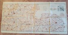 WWII Era - US ENGINEERS SPECIAL ROAD MAP OF ENGLAND & WALES (SHEET 5)
-
$47.82 GBP
 WWII Era - WAR AND NAVY DEPT. MAP OF ENGLAND & WALES (SHEET 2)
-
$25.00 GBP
 VINTAGE ADMIRALTY CHART. No.2110. CANADA NOVA SCOTIA. APPROACHES TO HALIFAX.1956
-
$44.00 GBP
 VINTAGE ADMIRALTY CHART. No.2753. New York. 1984.
-
$49.00 GBP
 VINTAGE ADMIRALTY CHART. No.3188. GULF of MEXICO. SABINE PASS. 1922
-
$23.02 GBP
 1812 Battle Monument Baltimore Engraving 1831 ORIGINAL ENGRAVING Fenner and Sear
-
$16.99 GBP
 VINTAGE ADMIRALTY CHART. No.293. CANADA NEWFOUNDLAND, GANDER BAY, BONAVISTA 1873
-
$49.00 GBP
 VINTAGE ADMIRALTY CHART. No. 2755. NEW YORK HARBOUR & APPROACHES. 1954.
-
$16.99 GBP
 VINTAGE ADMIRALTY CHART. No.893. CANADA NEWFOUNDLAND, MIQUELON, BURIN. 1883.
-
$29.99 GBP
 VINTAGE MARITIME CHART USA NANTUCKET SOUND & APPROACHES 1960 LITHOGRAPH MAP jax
-
$9.56 GBP
 1970 Map Maine Kennebek Sagadahok River Art Print Vintage 1750s Thomas Johnston
-
$35.00 GBP
 Antique map Dominion of Canada Western Sheet Keith Johnston c 1912
-
$300.00 GBP
 Antique Map "Carte Generale Des Etats-Unis Du Canada" A. Brué, 1825
-
$24.00 GBP
 VINTAGE ADMIRALTY CHART. No. 2866. CAPE CANAVERAL to KEY WEST. 1962
-
$47.82 GBP
 Vintage Camptonville Quad 7.5 Minute CA Map US Dept Int Geological Survey 1969
-
$67.75 GBP
 Antique Grand Canyon National Park USGS 1938 topo map 26" x 21" text on back
-
$182.54 GBP
 original Map: 1898 Massachusetts MARTHAS VINEYARD Sheet, aprox 20 X 16"
-
$31.88 GBP
 USGS Topo Map 7.5 Min Vintage : Caribou, CA 1979 BEAUTIFUL Rare California
-
$180.00 GBP
 Chart "Hampton Roads and Elizabeth River" (Norfolk-Virginia) U.K. Admiralty 1942
-
$80.00 GBP
 Antique Map "Royal Relief Atlas - North America" Phillips Bevan, 1885
-
$290.00 GBP
 Antique Map "Boston" (U.S.A.) John Tallis, 1851
-
$29.49 GBP
 1855 Eastern Montana Missouri River Basin ORIGINAL LITHOGRAPH Landscape View
-
$60.00 GBP
 Antique Map "Chart of Cooks River in the N.W. part of America" A. Hogg, 1778
-
$99.99 GBP
 1812 COLOUR MAP OF THE WORLD ON MERCATORS PROJECTION WESTERN PART BY NEELE *
-
$127.53 GBP
 Original Vintage Map:1899 Massachusetts WORCESTER Sheet, aprox 22 X 18"
-
$19.93 GBP
 Antelope Valley Kern Country Los Angeles California Vintage Real Estates Map 60s
-
$12.90 GBP
 VINTAGE ADMIRALTY CHART. No.2666. CANADA. GRAND BANKS OF NEWFOUNDLAND. 1973
-
$35.00 GBP
 Antique map Dominion of Canada Eastern Sheet Nova Scotia Keith Johnston c 1912
-
$5.00 GBP
 Antique Old Vintage MAP 1500's New England, America, Canada: 1556: Reprint
-
$49.00 GBP
 VINTAGE ADMIRALTY CHART. No.2831. PLANS in the GULF of MEXICO. 1955.
-
$89.99 GBP
 1925 Indexed Antique Map of Boston, Massachusetts by Walker Lithograph Co.
-
$290.00 GBP
 Antique Map "Carte De L'Amerique Septentrionale" (North America) A.Tardieu, 1821
-
$790.00 GBP
 Antique Map "Totius Americae Septentrionalis et Meridionalis" J. B. Homann, 1740
-
$19.92 GBP
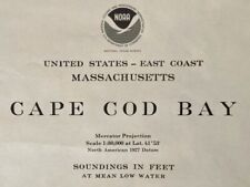 1977 Sea Chart Cape Cod Massachusetts USA Vintage Original Map Coastal Sailing
-
$474.22 GBP
 Rare ORIGINAL 1928 Rosalind Howe Sturges 'VASSAR FEMALE COLLEGE' Pictorial Map
-
$29.00 GBP
 Vintage Admiralty Sea Chart. No.320. NOVA SCOTIA. BEDFORD BASIN. HALIFAX. 1954
-
$5.99 GBP
 Antique Old Vintage Picture MAP 1800's New York, America 1851: Tallis: Reprint
-
$11.96 GBP
 Vintage 1962 USGS Topo Cox Comb Mountains, Joshua Tree, California 17 X 21"
-
$16.99 GBP
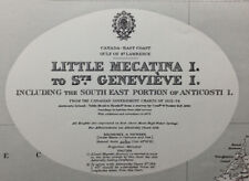 VINTAGE ADMIRALTY CHART. No.305. CANADA. QUÉBEC. MECATIRA & St GENEVIEVE 1937
-
$17.00 GBP
 Vintage Admiralty Sea Chart. No.296. NEWFOUNDLAND, CONCEPTION BAY. 1956 Edition
-
$4.99 GBP
 Canadian National Railways Map of Canada and the United States
-
$24.99 GBP
 1843 Canada Tegg Findlay Old Antique Map from "A Modern Atlas" Ottawa Montreal
-
$9.99 GBP
 Antique map 1880’s - USA- Authentic (taken from Encyclopaedia Britannica).
-
$29.00 GBP
 Vintage Admiralty Sea Chart. No.340. PORTS in S.E. COAST of NOVA SCOTIA. 1955
-
$22.95 GBP
 Antique NEW YORK Hydrographic Map: "Port de New York" LEMERCIER ca. 1890 SCARCE
-
$35.87 GBP
 1998 California Map Newport Beach SAN DIEGO Los Angeles Santa Monica BEAUTIFUL
-
$4.99 GBP
 Vintage National Geographic Map - USA 1976 - 106cm x 74cm
-
$10.00 GBP
 1903 Black ASIA SIBERIA CENTRAL ASIA Antique Map
-
$29.49 GBP
 1855 Montana Rocky Mountains ORIGINAL LITHOGRAPH Lewis Clark Pass RARE
-
$12.00 GBP
 Antique Map. DOMINION OF CANADA. 1876. VG.
-
$6.50 GBP
 1851 Vuillemin EUROPE Antique Map
-
$89.99 GBP
 1815 Antique Map; North America
-
$3800.00 GBP
 Antique Map "A New Mapp of Carolina" (USA) J. Thornton, 1748
-
$4.78 GBP
 1897 Map North part of United States Original antique print USA
-
$15.00 GBP
 Bartholomew's General map of North America. Scale 1: 10,000,000. A linen classic
-
$75.00 GBP
 1758 Map, “Rade et Ville de la Vera-Cruz, Vera Cruz, Mexico, by Schley
-
$15.00 GBP
 Copy of Antique Map of Boston, Massachusetts 1769 Dedicated to Jonathan Belcher
-
$16.99 GBP
 VINTAGE ADMIRALTY CHART. No.2915.CANADA.NEWFOUNDLAND. BAY BULLS to PLACENTA 1864
-
$19.99 GBP
 1842 Antique Map; Canada - Alexander Findlay
-
$75.00 GBP
 ADMIRALTY MAP/SEA CHART- ENGLAND SOUTH & WEST COAST-TREVOSE HEAD TO DODMAN-1955
-
$5.00 GBP
 Unusual Antique Old MAP 1700's Hudson's Bay, Labrador Canada 1743: Reprint
-
$15.90 GBP
 Georgetown South, South Carolina 1943 Revised 1973 Original USGS Topo Map
-
$16.99 GBP
 VINTAGE ADMIRALTY CHART. No.2342. CANADA NOVA SCOTIA. CHEDABUCTO BAY. 1968
-
$60.00 GBP
 ADMIRALTY MAP/SEA CHART-ENGLISH CHANNEL- NEWHAVEN TO CALAIS-1955/1967
-
$65.00 GBP
 ADMIRALTY MAP/SEA CHART- ENGLISH CHANNEL - NEWHAVEN TO CALAIS- 1955/1972
-
$16.99 GBP
 VINTAGE ADMIRALTY CHART. No.284. CANADA. NEWFOUNDLAND COAST. 1884.
-
$9.80 GBP
 AAF AERONAUTICAL CHART STRAIT OF BELLE ISLE (223) 1943 - 1945 MAP 28" x 21''
-
$16.99 GBP
 VINTAGE ADMIRALTY CHART. No.779. CANADA NEWFOUNDLAND, STRAIT of BELLE ISLE.1899
-
$25.00 GBP
 NORTH AMERICA, UNITED STATES, CANADA Blackie original antique map 1882
-
$29.39 GBP
 2007 Aspen Colorado Map Pictorial Chris King Ski Hill Alps Main Street LARGE
-
$15.00 GBP
 Antique Map. CANADA, NEW BRUNSWICK, NOVA SCOTIA &c. J. Bartholomew. Undated. VG.
-
$65.00 GBP
 ADMIRALTY MAP/SEA CHART- ENGLISH CHANNEL - NEWHAVEN TO CALAIS- 1955
-
$18.99 GBP
 New York, United States in 1840, town plan
-
$7.97 GBP
 US Army Welfare Services Brussels Map from Occupied Europe
-
$37.62 GBP
 Historic Map Groton Conn 1655-1799 Town Owner Names Genealogy Date Unknown
-
$159.40 GBP
 1852 Historic Map - Location of Indian Tribes within the United States
-
$35.77 GBP
 1855 Teton Valley Wyoming Idaho ORIGINAL LITHOGRAPH Landscape View Hand-Colored
-
$65.00 GBP
 ADMIRALTY MAP/SEA CHART- NORTH SEA -HARWICH TO TERSCHELLING & ROTTERDAM-1958/73
-
$15.00 GBP
 Niagra Falls Tour Map By Kiwanis. Map. Travel Map. Map Of Canada. Map Of USA.
-
$6.50 GBP
 1851 Vuillemin PERSE KABOUL Antique Map
-
$65.00 GBP
 ADMIRALTY SEA CHART-ENGLAND SOUTH COAST-PRAWLE POINT TO HENGISTBURY HEAD-1957
-
$15.90 GBP
 Pelham, Georgia 1971 Original Vintage USGS Topo Map
-
$65.00 GBP
 ADMIRALTY MAP/SEA CHART- ENGLAND SOUTH COAST - DOVER HARBOUR - 1955/1964
-
$10.00 GBP
 Antique Map. Undated. UNITED STATES. Bartholomew. G+.
-
$31.87 GBP
 San Pedro Channel Map Chart C&GS 5142
-
$14.35 GBP
 Map Schoodic Maine 1984 Topographic Geological Survey 1:24000 27 x 22" TOPO6


