 Antiques (UK)
-
$35.00 GBP

 WELSHPOOL, POWYS, WALES, Street Plan, Dawson original antique map 1832
-
$19.95 GBP
 WALES, POWYS, RHAYADER,LLANSANTFFRAED, Boundaries Commission Antique Map 1868
-
$13.12 GBP
 1895 Brecknock county map. Victorian. Wales County. Brecon Beacons, Crickhowel.
-
$15.44 GBP
 1908 England South West & Wales large map. 115 years old. Bristol, Cardiff.
-
$18.90 GBP
 Antique old map of Wales Cambriae Typus Mercator, Hondius 1606 art print poster
-
$12.99 GBP
 1932 WAR OFFICE MAP - LLANDRINDOD WELLS WALES - LMS GWR RAILWAY
-
$9.99 GBP
 Cymru Wales Welsh Reproduction Antique Old Colour Color Map by Gerard Mercator
-
$38.00 GBP
 BRECON, BRECKNOCK, WALES, Street Plan, Dawson Original antique map 1832
-
$11.99 GBP
 Vintage Ordnance Survey Map of Wales and the Marches (1959) Welsh, Quarter Inch
-
$30.00 GBP
 Brecknockshire, now in Powys, antique map 1769 by G. Rollos
-
$18.99 GBP
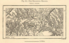
 Brecknock or Brecon Beacons. Abergavenny Crickhowell. Powys. Sketch map 1885
-
$22.47 GBP
 Vintage framed Hand Stitched Map Of England And Wales 20.5" x 16.5"
-
$18.00 GBP
 Brecknock or Brecon Beacons. Abergavenny Crickhowell. Powys. Sketch map 1885
-
$44.00 GBP
 WALES (South East) Glamorgan Brecknock Radnorshire Powys GW BACON 1891 old map
-
$8.99 GBP
 1894 Vintage antique County Map of Radnor Radnorshire Powys by FS Weller colour
-
$42.00 GBP
 WALES (South East) Glamorgan Brecknock Radnorshire Powys GW BACON 1883 old map
-
$24.99 GBP
 BRECON MAP - Sheet 141 - One-Inch Ordnance Survey Map - 7th Edition
-
$27.50 GBP
 1868 Powys Wales Boundary Commission Ordnance MAP PLAN of BRECON (BC198)


