 Antiques (UK)
Africa Maps
Asia Maps
Australia/Oceania Maps
Celestial Maps
Central America/Caribbean Maps
Curiosities Maps
Digital Maps
Europe Maps
Map & Globe Mixed Lots
Map & Globe Reproductions
North America Maps
South America Maps
World & Celestial Globes
World Maps

-
$127.88 GBP

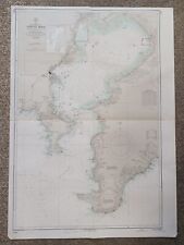 1935 Tokyo Wan Japan Hydrographic Survey Map
-
$20.03 GBP
 1893 GEOLOGICAL WORLD MAP Earth Surface Map Vintage ORIGINAL 11.5 x 9.5" C11-7
-
$24.13 GBP
 map Germany WW2 westlicher Kriegsschauplatz Leipzig 1940
-
$68.36 GBP
 Johnson's 1864 colored map of Ocean Currents & Principal Plants
-
$19.00 GBP
 Canary Islands Atlantic Ocean Climate Currents Isothermals SAMLER BROWN 1932 map
-
$25.00 GBP
 OCEAN CURRENTS OF THE WORLD, original antique atlas map, A.K. Johnston, 1853
-
$38.00 GBP
 North Atlantic Ocean showing Gulf Stream, currents & Sargasso Sea LOWRY 1860 map
-
$8.00 GBP
 VINTAGE ORIGINAL COLOUR MAP-ATLANTIC OCEAN- PUBL.W&R CHAMBERS LTD.- 1901
-
$8.99 GBP
 Atlantic Winds and Currents. Atlantic Ocean 1885 old antique map plan chart
-
$12.00 GBP
 World physical features ocean currents ethnographical religions 1854 old map
-
$14.00 GBP
 NORTH ATLANTIC OCEAN. Telegraph cables/dates. Ocean currents/velocities 1882 map
-
$18.00 GBP
 NORTH ATLANTIC OCEAN, CURRENTS, DEPTHS, original antique map, Blackie, 1882
-
$9.00 GBP
 Apparent Anomalies in the Gulf Stream surface current.Atlantic Ocean 1885 map
-
$22.52 GBP
 1890 WORLD OCEAN CURRENTS Antique Map
-
$20.03 GBP
 1893 OCEAN CURRENTS Temperature Map Vintage Eng ORIGINAL 11.5 x 9.5" C12-4
-
$50.27 GBP
 Indian Ocean Southern Africa India Southeast Asia Currents 1856 information map
-
$48.00 GBP
 NEW ZEALAND Lighthouses railways telegraph cables ocean currents. LETTS 1883 map
-
$31.00 GBP
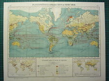
 World Vegetation and Ocean Currents Map from the 1920 Times Atlas (Plate 4)
-
$65.00 GBP
 CAPE OF GOOD HOPE COAST SOUTH AFRICA ADMIRALTY SEA CHART 1867 (1949) OLD MAP
-
$9.00 GBP
 Climate Chart, Ocean Currents & Land cultivation. World. BARTHOLOMEW 1893 map
-
$30.00 GBP
 Original antique map WORLD MAP, OCEAN CURRENTS, TELEGRAPH LINES, Stieler, 1889
-
$15.00 GBP
 NORTH ATLANTIC OCEAN. Telegraph cables/dates. Ocean currents/velocities 1886 map
-
$14.00 GBP
 WORLD. Land surface features and Ocean currents. BARTHOLOMEW 1890 old map
-
$50.00 GBP
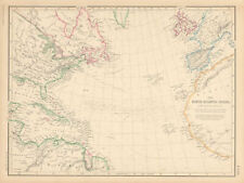
 BASIN OF THE NORTH ATLANTIC OCEAN, large original antique map, Johnston, 1871
-
$12.99 GBP
 1876 Antique map - North Atlantic Ocean, Gnomonic Projection - Bartholomew
-
$44.00 GBP
 Map: 1890 Bartholomew; World: Land Surface Features and Ocean Currents - Sheet 3
-
$105.00 GBP
 Vintage Map Italian Govt Provisional Chart Gulf of Venice Mediterranean Sea 1956
-
$6.00 GBP
 WORLD. Climate commercial products; Isotherms Ocean Currents Jan July 1907 map
-
$14.48 GBP
 VINTAGE MAPS
-
$38.20 GBP
 New Zealand 1883 Lett's map shows ocean currents submarine telegraph lines
-
$20.03 GBP
 1893 OCEAN CURRENTS Temperature Map Vintage Eng ORIGINAL 11.5 x 9.5" C11-7
-
$30.16 GBP
 Currents of the Pacific Ocean Australia Polynesia New Zealand 1849 Berghaus map
-
$14.44 GBP
 1916 Antique Map of The World Original Color Ocean Currents & Routes Railroads
-
$14.99 GBP
 Original c1925 Antiquarian Times Map of World Vegitation and Ocean Currents
-
$18.00 GBP
 PACIFIC OCEAN currents British French German US Spanish colonies. LETTS 1889 map
-
$30.00 GBP
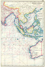 INDIAN OCEAN EAST. East Indies. Shows winds & ocean currents 1920 old map
-
$38.00 GBP
 North Atlantic Ocean showing Gulf Stream, currents & Sargasso Sea LOWRY 1859 map
-
$34.00 GBP
 INDIAN OCEAN WEST. Africa. British Empire.Shows winds & ocean currents 1920 map
-
$21.28 GBP
 1899 ANTIQUE MAP OF THE WORLD VEGETATION OCEAN CURRENTS PLANTS AMERICA ASIA
-
$51.70 GBP
 .1922 INTERESTING LARGE MAP of THE WORLD. VEGETATION & OCEAN CURRENTS.
-
$23.00 GBP
 JAMAICA. Ocean current directions 1889. Caribbean. USCGS 1889 old antique map
-
$23.00 GBP
 HISPANIOLA. Ocean current directions 1888. Cuba Puerto Rico. USCGS 1889 map
-
$22.00 GBP
 PACIFIC OCEAN & ISLANDS. Australasia. Currents. LETTS 1883 old antique map
-
$23.00 GBP
 HISPANIOLA. Ocean current directions 1889. Cuba Puerto Rico. USCGS 1889 map
-
$37.00 GBP
 World. Cotidal Ocean lines currents Meteorology plants animals COLTON 1869 map
-
$39.00 GBP
 WORLD. Mercator's projection. Ocean currents & shipping routes. BLACKIE 1886 map
-
$38.00 GBP
 1942 MAP ~ WORLD RAINFALL ~ JANYARY WINDS OCEAN CURRENTS JULY & MEAN ANNUAL
-
$20.00 GBP
 South Atlantic Ocean. Shipping routes currents ocean depths. THE TIMES 1922 map
-
$19.00 GBP
 ATLANTIC OCEAN. Showing currents & isothermals. Britannica 9th edition 1898 map
-
$13.99 GBP
 Currents of the South Atlantic and Lines of Icebergs. Atlantic Ocean 1885 map
-
$30.00 GBP
 World. Vegetation. Ocean currents. Continental cross sections. TIMES 1922 map
-
$12.00 GBP
 World physical features ocean currents ethnographical religions 1856 old map
-
$22.52 GBP
 1902 Century Map Physical World in Hemispheres South Pole Antarctica Mountains
-
$128.00 GBP
 1899 LARGE ANTIQUE MAP WORLD OCEAN CURRENTS STEAMER ROUTES INDIA ASIA AMERICA
-
$38.50 GBP
 1931 MAP ~ EUROPE VEGETATION FOREST WOODLAND DESERTS MOUNTAINS OCEAN CURRENTS
-
$78.00 GBP
 1873 HAND COLOURED MAP CHART OF THE WORLD OCEAN CURRENTS PORTS ROUTES
-
$12.87 GBP
 1874 Johnson Map World Ocean Currents River Basins Trade Winds Gulf Stream Tide
-
$38.00 GBP
 1939 MAP NORTH ATLANTIC 1715 NAVAL WARS NARROW SEAS OCEAN CURRENTS
-
$48.00 GBP
 1921 MAP ~ THE WORLD ON MERCATORS PROJECTION OCEAN CURRENTS VEGETATION
-
$43.00 GBP
 North Atlantic Ocean. Shipping routes & currents. Depths. THE TIMES 1922 map
-
$88.00 GBP
 1891 ANTIQUE MAP CHART OF WORLD MARCATORS POLYNESIA AMERICAS ASIA OCEAN CURRENTS
-
$15.00 GBP
 USA. Gulf stream. 1888-1889 Ocean current observations IV. USCGS 1889 old map
-
$16.09 GBP
 1861 Original A.K.Johnston Map - CHART OF THE WORLD - Ocean Currents & Distances
-
$15.00 GBP
 USA. Gulf stream. 1888-1889 Ocean current observations III. USCGS 1889 old map
-
$15.00 GBP
 USA. Gulf stream. 1888-1889 Ocean current observations I. USCGS 1889 old map
-
$26.00 GBP
 WORLD VEGETATION & OCEAN CURRENTS & vertical distribution of vegetation 1912 map
-
$15.00 GBP
 USA. Gulf stream. 1888-1889 Ocean current observations II. USCGS 1889 old map
-
$20.91 GBP
 1910s Imperial Russian Antique map of WORLD PRECIPITATION and SEA STREAMS
-
$95.00 GBP
 World Land features. Co-tidal Lines. Ocean currents. Watersheds JOHNSON 1861 map
-
$48.00 GBP
 1895 VICTORIAN MAP ~ THE WORLD OCEAN CURRENTS JULY RIVER BASINS C0-TIDAL LINES
-
$35.00 GBP
 Worldl. Cotidal Ocean lines currents Meteorology plants animals COLTON 1863 map
-
$40.00 GBP
 NEW ZEALAND Lighthouses railways telegraph cables ocean currents. LETTS 1889 map
-
$95.00 GBP
 World. Animals Birds Industries Ocean Currents Watersheds. JOHNSON 1866 map
-
$68.00 GBP
 1958 LARGE MAP WORLD SURFACE ROUTES GULF STREAM OCEAN CURRENTS SHIP CANALS
-
$24.13 GBP
 WWII map Germany WW2 Turkey Italian Italy German Kriegsschauplatz Leipzig 1940's
-
$60.00 GBP
 INDIAN OCEAN. British colonies/Empire. Winds currents Steamship routes 1920 map
-
$58.00 GBP
 1882 LARGE ANTIQUE MAP ~ NORTH ATLANTIC OCEAN CURRENTS BRITISH ISLES WEST INDIES
-
$48.00 GBP
 1871 ANTIQUE MAP WORLD SHOWING OCEAN CURRENTS GREAT RIVER BASINS AFRICA EUROPE
-
$38.00 GBP
 1873 MAP OCEANIC CURRENTS NORTH & SOUTH AMERICA EUROPE AFRICA HUMBOLDTS
-
$58.00 GBP
 1875 ANTIQUE MAP ATLANTIC OCEAN WINTER ISOTHERMALS WARN CURRENTS
-
$95.00 GBP
 World. Animals Birds Industries Ocean Currents Watersheds. JOHNSON 1865 map
-
$16.08 GBP
 1883 Johnston Royal Atlas Map - World - Steamboat Routes & Ocean Currents
-
$32.50 GBP
 1934 MAP ~ ATLANTIC OCEAN WITH SHIPPPING ROUTES OCEAN CURRENTS ~ SOUTH AMERICA
-
$38.00 GBP
 1908 MAP ~ OCEAN WARM & COLD CURRENTS AUSTRALIA NEW ZEALAND EAST INDIES AMERICA
-
$58.00 GBP
 1881 MAP ~ WORLD TRADE OCEAN CURRENTS MERCATOR PROJECTION LAND HEIGHTS VOLCANOES
-
$48.00 GBP
 1943 MAP THE WORLD ~ TEMPERATURES OCEAN CURRENTS ECONOMY ECONOMIC FORMS
-
$12.86 GBP
 1849 Bilder Atlas Map - Europe - Ocean Currents Alps Mountains Climate Temps
-
$44.00 GBP
 1902 ANTIQUE MAP ~ THE WORLD SHOWING OCEAN CURRENTS CLIMATE CHART WIND RAINFALL
-
$58.00 GBP
 1897 ANTIQUE MAP WORLD SHOWING OCEAN CURRENTS GREAT RIVER BASINS SEA DEPTHS
-
$48.00 GBP
 1901 VICTORIAN MAP ~ THE WORLD ~ PREVAILING WINDS OCEAN CURRENTS ANNUAL RAINFALL
-
$48.00 GBP
 1899 VICTORIAN MAP ~ THE WORLD ~ ANNUAL RAINFALL OCEAN CURRENTS CLIMATE CHART
-
$43.00 GBP
 Indian Ocean. Shipping routes, currents & depths. THE TIMES 1922 old map
-
$58.00 GBP
 1913 MAP OCEAN CURRENTS & CLIMATES EUROPE AFRICA ANNUAL RAINFALL SIBERIA
-
$58.00 GBP
 1913 MAP OCEAN CURRENTS & CLIMATES WESTERN SECTION AMERICAS WINDS RAINFALL
-
$58.00 GBP
 1892 VICTORIAN MAP ~ CHART OF THE WORLD SHOWING OCEAN CURRENTS FORMS DIRECTIONS
-
$58.00 GBP
 1880 MAP CHART OF THE WORLD OCEAN CURRENTS COTIDAL LINES MOUNT EVEREST TIDAL
-
$44.00 GBP
 1897 VICTORIAN MAP ~ CLIMATOLOGICAL CHART MEAN TEMPERATURES OCEAN CURRENTS
-
$48.00 GBP
 1908 ANTIQUE MAP ~ WORLD WESTERN & EASTERN HEMISPHERES OCEAN CURRENTS
-
$22.51 GBP
 1873 Guyot World Map Tidal Waves & River Basins Ocean Currents Tide Surf Antique
-
$28.95 GBP
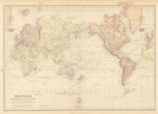
 1892 Rand McNally World Map Ocean Currents America Asia Africa Australia 14x21"


