-

$49.00 GBP
 VINTAGE ADMIRALTY CHART. No. 1185. RIVER THAMES, SEA REACH. 1962 EDITION.
-
$19.99 GBP
 1883 Kent Hand Coloured Original Antique County Map by G.W. Bacon
-
$49.00 GBP
 VINTAGE ADMIRALTY CHART. No.2451. OWERS to DUNGENESS. 1920 Edition.
-
$25.99 GBP
 Rare vintage antique map of south of england EAST KENT , 1921 Ordnance Survey
-
$19.99 GBP
 Chislet, Old Tree OS Kent 36-2-1938 old map repro
-
$115.00 GBP
 Antique map Brabourne,Hythe,Sellindge,Smeeth,Elmsted,Postling,Kent E.Hasted 1790
-
$15.99 GBP
 Old map Environs of Dartford , Kent - 1898
-
$18.99 GBP
 Old Map Wilmington, Hextable, Swanley Village OS Kent 9-SW-1908
-
$17.99 GBP
 Old Map of Dover, Kent in the 1600's - town plan, repro, vintage, historical
-
$49.00 GBP
 VINTAGE ADMIRALTY CHART. No.1610. THAMES. N. FORELAND to ORFORDNESS. 1933 Edn.
-
$35.00 GBP
 KENT, MONKTON, RAMSGATE, TUNBRIDGE WELLS, original antique road map, MOGG, 1817
-
$115.00 GBP
 WACHLINGSTONE HUNDRED, KENT Tonbridge, Tunbridge Wells, Hasted Antique Map 1782
-
$25.00 GBP
 Tottenham, Tower Hamlets, Higham Hill antique map 1904.
-
$49.00 GBP
 VINTAGE ADMIRALTY CHART. No. 1828. THE DOWNS. 1932 Edition.
-
$49.00 GBP
 VINTAGE ADMIRALTY CHART. No.1150. RIVER THAMES, ERITH to BROADNESS. 1940 Edn.
-
$49.00 GBP
 ANTIQUE ADMIRALTY CHART. No.2572.WEST SWALE, FOWLEY to QUEENBOROUGH. 1918 Edn.
-
$135.00 GBP
 Antique Map DARTFORD HUNDRED, KENT Plumstead Crayford Erith Welling, Hasted 1778
-
$19.99 GBP
 Old, Vintage,Tonbridge (north), Cage Green OS Kent 50-8-1908
-
$65.00 GBP
 Hasted, Kent. The Hundreds of Wrotham and Littlefield antique map 1793,
-
$24.99 GBP
 1720 Bowen Kent & Essex Road Map Dover Canterbury Deal Chelmsford Maldon Ogilby
-
$15.99 GBP
 Old map Environs of Sittingbourne, Kent - 1898
-
$14.95 GBP
 1898 Mouth of the Thames, North Kent & Essex large map. 125 yrs old. Canterbury.
-
$55.00 GBP
 Hasted. The Hundreds of Felborough & Wye. 1793.
-
$6.99 GBP
 1927 Ordnance Survey Half Inch Road Linen Map 40 Chatham , Margate And Hastings
-
$17.99 GBP
 Old map Oare, Faversham (north) OS Kent 34-NW-1909 old map repro A2
-
$30.00 GBP
 South Norwood, West Wickham, Croydon antique map 1904.
-
$115.00 GBP
 Antique map KENT AXTANE HUNDRED Greenhithe Southfleet Farningham, Hasted 1778
-
$14.99 GBP
 Goodwin Sands. Deal Sandwich Ramsgate. Kent. Sketch map 1885 old antique
-
$35.00 GBP
 Framed Vodka map of the UK
-
$69.95 GBP
 Original 1914 OS Map Sheet Addington Prk West Wickham Shirley Croydon Springpark
-
$49.00 GBP
 VINTAGE ADMIRALTY CHART. No.1827. RIVER STOUR to RAMSGATE HARBOUR. 1959 Edition
-
$18.90 GBP
 River Thames antique Victorian excursions guide map Eton to Nore 1849 art poster
-
$20.00 GBP
 Eltham, Chislehurst antique map 1904.
-
$75.00 GBP
 Hasted, Kent. The Isle of Thanet, Hundred of Ringslow- genuine antique map 1793.
-
$14.75 GBP
 North Foreland Kent Thanet Cloth Sectional Map 1931 Original Sifton Praed
-
$65.00 GBP
 The Hundreds of Calehill, Chart & Longridge - antique map 1793 by Hasted.
-
$70.00 GBP
 Hasted, Kent. The Hundreds of Tenterden, Blackborne, Oxney & Ham. 1793
-
$17.99 GBP
 Old map of Chiddingstone and Hever Kent in 1937 49 SE A2
-
$69.95 GBP
 Original 1910 OS Sheet Map Bexleyheath Blackfen Upton Halfway St Watling Bromley
-
$30.00 GBP
 Dugdale & Neele 1819 Antique Map. Kent
-
$80.00 GBP
 Hasted, Kent. The Hundreds of Westgate, Whitstable, Blengate & Preston - 1793
-
$18.99 GBP
 Old map - Tilmanstone - Northbourne OS Kent 58 NW- 1908
-
$19.99 GBP
 Maidstone, Tonbridge, Shipbourne, Kent 1769 sheet 3-2
-
$20.00 GBP
 Sea Chart Map English Channel Newhaven to Calais 2451 Dover Strait Rye Harbour
-
$24.00 GBP
 ANTIQUE MAP BY BACON of TUNBRIDGE WELLS in Kent - 1884
-
$18.99 GBP
 Old map Ramsgate (west), Cliffsend, Thorne, Pegwell OS Kent 37-NE-- 1908
-
$18.99 GBP
 Old Map Belvedere, Bexleyeath old OS Kent map 2-SW/SE- - repro 1910
-
$125.00 GBP
 1829 Greenwood Kent Genuine Antique Map Large 75x64cms Canterbury Cathedral RARE
-
$145.00 GBP
 KENT MAIDSTONE BY WILLIAM MUDGE c1819 GENUINE 1st EDITION ORDNANCE SURVEY MAP
-
$18.99 GBP
 Old Map Stelling Minnis, Bossingham, Bladbean Kent 56-SE- 1908
-
$18.99 GBP
 Old map Cowden (E), Markbeech, The Hoath OS Kent 59-NE-1910
-
$15.99 GBP
 circa 1880s map of kent ! ( adam & charles black )
-
$23.00 GBP
 East Kent & White cliffs of Dover coast profile. MOUNT & PAGE 1758 old map
-
$20.99 GBP
 KENT 1610 by John Speed - reproduction old map - fits A2 frame
-
$19.99 GBP
 Chainhurst OS Kent 52-6-1908 old map repro
-
$135.00 GBP
 Antique Map CALEHILL HUNDRED, KENT, Ashford, Great Chart, Charing, E.Hasted 1790
-
$18.99 GBP
 Old map Hoo, Upnor old OS Kent map 11-SE- 1909
-
$18.99 GBP
 Old map - Shepherdswell - Coldred - OS Kent 57-SE- 1908
-
$14.95 GBP
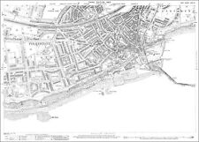
 1898 Kent coast, Folkestone & Strait of Dover large map. 125 years old. Hastings
-
$18.99 GBP
 Old Map - Badlesmere - Sheldwich - Molash OS Kent 45 SW 1908
-
$49.00 GBP
 ANTIQUE ADMIRALTY CHART. No.2151. RIVER THAMES, GRAVESEND, LOWER REACH. 1907 Edn
-
$80.00 GBP
 Hasted, Kent. Sandwich. The Hundred of Eastry. 1793
-
$17.99 GBP
 Old map Cranbrook, Sissinghurst OS Kent 70-NE-1938 A2
-
$18.99 GBP
 Old map Rainham, Wigmore, Hartlip ETC OS Kent 20-SW--1908
-
$19.99 GBP
 Egerton OS Kent 54-9-1907 old map repro
-
$14.99 GBP
 Kent Antique Colour Map Thomas Moule County Maps of Old England 14“
-
$18.99 GBP
 Old Map Shipbourne, Ightham Mote OS Kent 40-SE 1909
-
$75.00 GBP
 Hasted, Kent. The Hundred of Eyhorne 1793 - genuine original.
-
$18.99 GBP
 Old map Rochester, Strood old OS Kent map 19-NW - 1910
-
$19.99 GBP
 Folkestone OS Kent 75-10-1907 old map repro
-
$15.00 GBP
 TUNBRIDGE WELLS,MAIDSTONE,KENT Antique Copper Engraved Vintage Map 1804
-
$20.00 GBP
 MAIDSTONE borough/town plan. BOUNDARY COMMISSION. Kent. DAWSON 1837 old map
-
$18.99 GBP
 Old map Yalding - East Peckham - OS Kent 51 NE- 1909
-
$135.00 GBP
 Antique Map MAIDSTONE HUNDRED KENT, Boxley, Detling, Linton, Loose, Hasted 1782
-
$14.99 GBP
 1805 Antique Map: The Coast from Sandwich to Winchelsea, Sussex / Kent
-
$18.99 GBP
 Old Map Bexley heath - Bexley - Halfway st OS Map 8 NE 1910
-
$18.99 GBP
 Old Map Egerton, Pluckley, Little Chart OS Kent 54-SW-1909
-
$17.99 GBP
 Old map Sandwich OS Kent 48-NE-1938 repro A2
-
$5.00 GBP
 VINTAGE GEOGRAPHIA FOOTPATHS MAP OF SE KENT - PREPARED FOR RAMBLERS
-
$19.99 GBP
 Whitstable (north), Tankerton OS Kent 23-10-1932
-
$17.99 GBP
 Old Map , Ottinge OS Kent 66-SE-1939 A2
-
$60.00 GBP
 LONDON TO DOVER KENT ROAD MAP BY JOHN OGILBY REDUCED BY THOMAS GARDNER c1719
-
$17.99 GBP
 Old Map Frittenden, Sissinghurst Castle OS Kent 63-SW-1909 A2
-
$18.99 GBP
 Old Map Frittenden, Sissinghurst Castle OS Kent 63-SW-1909
-
$18.99 GBP
 Old Map Tunbridge Wells OS Kent 60-SE - 1910
-
$12.99 GBP
 Original Antique Map of KENT, Bacon Circa 1900
-
$18.99 GBP
 Old Map Trottiscliffe, Stansted, Fairseat old OS Kent map 30-NW- 1909
-
$3.50 GBP
 Bartholomew's revised half inch map of Kent - Cloth (map #10)
-
$33.00 GBP
 Rochester, Kent. JAMES. Parliamentary Boundary Commission 1868 old antique map
-
$80.00 GBP
 Hasted. The Hundreds of Cornilo & Bewsborough with the towns of Deal and Dover.
-
$9.99 GBP
 c1835 Maidstone Sandwich Deal Kent Map Town Plan Creighton Lewis Handcoloured
-
$19.99 GBP
 Rochester & Strood (S), Borstal (N) old OS Kent map 19-6-1934
-
$17.99 GBP
 Old map Great Chart (S), Chilmington Green OS Kent 64-SE-1938 repro A2
-
$14.99 GBP
 MAP OF KENT 1800'S 51 x 41cm WRIGHTSONS FOILGRAPHICS 1985 REPRODUCTION
-
$6.99 GBP
 CANTERBURY Kent Town Plan Vintage Folding Map c1935
-
$19.95 GBP
 1906 ANTIQUE ORDNANCE SURVEY MAP EAST KENT SOUTH 1 INCH SHEET - ASHFORD DOVER
-
$17.99 GBP
 Belvedere (north) old OS Kent map 2-NE-1938 - repro
-
$65.00 GBP
 1779 Hasted Kent Dartford Crayford Plumstead Welling Thames Detailed Antique Map
-
$69.95 GBP
 Original 1909 OS Map Sheet Seal Ightham Ivy Hatch Styants Bottom Oldbury Stone S
-
$39.00 GBP
 VINTAGE ADMIRALTY CHART. No.1975. RIVER THAMES ENTRANCE. 1958 Edition.


