
-
$19.99 GBP

 1884 Eastern United States Hand Coloured Original Antique Map by Johnston
-
$19.99 GBP
 1889 North America Hand Coloured Original Antique Map by Johnston
-
$24.99 GBP
 1872 Quebec & Maine Fully Hand Coloured Antique Map by The SDUK
-
$24.99 GBP
 1860 Eastern Canada Hand Coloured Antique Map by G.W. Blackie
-
$6.50 GBP
 1902 state map of Texas Western Part antique vintage Britannica 10th
-
$6.50 GBP
 1902 state map of Missouri Southern Part antique vintage Britannica 10th
-
$6.50 GBP
 1902 state map of Louisiana antique vintage Britannica 10th
-
$6.50 GBP
 1902 state map of Minnesota antique vintage Britannica 10th
-
$6.50 GBP
 1902 state map of North Carolina antique vintage Britannica 10th
-
$6.50 GBP
 1902 state map of Mississippi antique vintage Britannica 10th
-
$6.50 GBP
 1902 state map of Texas Eastern Part antique vintage Britannica 10th
-
$6.50 GBP
 1902 state map of Ohio Southern Part antique vintage Britannica 10th
-
$6.50 GBP
 1902 state map of Montana antique vintage Britannica 10th
-
$19.99 GBP
 1884 Western United States Hand Coloured Original Antique Map by Johnston
-
$19.99 GBP
 1908 Nova Scotia Original Antique Map by G.W. Bacon
-
$19.99 GBP
 1850 Principal Cities of The United States by G.H Swanston Original Antique Map
-
$6.50 GBP
 1902 state map of Washington antique vintage Britannica 10th
-
$6.50 GBP
 1902 state map of Illinois Southern Part antique vintage Britannica 10th
-
$6.50 GBP
 1902 state map of Wisconsin antique vintage Britannica 10th
-
$6.50 GBP
 1902 state map of Alabama antique vintage Britannica 10th
-
$6.50 GBP
 1902 state map of Iowa antique vintage Britannica 10th
-
$5.00 GBP
 1902 Map of the United States of America antique vintage Britannica 10th
-
$5.00 GBP
 1902 Map of Manitoba British Columbia antique vintage Britannica 10th
-
$60.00 GBP
 1816 LARGE ANTIQUE COPPER PLATE MAP SPANISH NORTH AMERICA SOUTHERN PART THOMSON
-
$6.50 GBP
 1902 state Map of Pennsylvania Western part antique vintage Britannica 10th
-
$6.50 GBP
 1902 state Map of Georgia antique vintage Britannica 10th
-
$5.00 GBP
 1902 state map of Virginia antique vintage Britannica 10th
-
$10.00 GBP
 1909 map street plan of Boston Massachusetts USA antique vintage Baedeker
-
$19.99 GBP
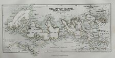 1850 Wellington Channel Arctic Regions Canada by G.H. Swanston Antique Map
-
$19.99 GBP
 1897 Illinois Original Antique Map by A & C Black
-
$19.99 GBP
 1893 Dominion of Canada Original Antique Map by G.W. Bacon
-
$19.99 GBP
 1897 British Columbia, Athabasca, Alberta Original Antique Map by A & C Black
-
$6.50 GBP
 1902 state map of Missouri Northern Part antique vintage Britannica 10th
-
$6.00 GBP
 1909 map street plan of New Haven Connecticut USA antique vintage Baedeker
-
$6.50 GBP
 1902 state map of Oregon antique vintage Britannica 10th
-
$6.50 GBP
 1902 state Map of Pennsylvania Eastern part antique vintage Britannica 10th
-
$6.50 GBP
 1902 state map of South Carolina antique vintage Britannica 10th
-
$6.50 GBP
 1902 state map of Nebraska antique vintage Britannica 10th
-
$19.99 GBP
 1896 Northeast United States Original Antique Map 125 Years Old
-
$79.66 GBP
 1851 WEST CANADA LAKE ONTARIO HURON ERIE ORIGINAL TALLIS MAP 11x14 WM83
-
$6.50 GBP
 1902 state map of Arkansas antique vintage Britannica 10th
-
$6.50 GBP
 1902 state map of Arizona and New Mexico antique vintage Britannica 10th
-
$6.50 GBP
 1902 state map of Kansas antique vintage Britannica 10th
-
$6.50 GBP
 1902 state map of Michigan Northern Part antique vintage Britannica 10th
-
$6.50 GBP
 1902 state map of California Southern Part antique vintage Britannica 10th
-
$6.50 GBP
 1902 Map of New York Northern and Eastern Part antique vintage Britannica 10th
-
$40.00 GBP
 1836 LARGE ANTIQUE MAP NORTH AMERICA - DUFOUR - L'AMERIQUE DU NORD
-
$6.50 GBP
 1902 Map of Ontario antique vintage Britannica 10th
-
$6.50 GBP
 1902 state map of Indiana antique vintage Britannica 10th
-
$4.99 GBP
 CITIES & PORTS in CANADA - 1856 Antique Map by SWANSTON
-
$6.50 GBP
 1902 state Map of Vermont and New Hampshire antique vintage Britannica 10th
-
$6.50 GBP
 1902 state map of Colorado antique vintage Britannica 10th
-
$10.00 GBP
 1909 map street plan of Buffalo New York USA antique vintage Baedeker
-
$6.50 GBP
 1902 state map of Kentucky antique vintage Britannica 10th
-
$6.50 GBP
 1902 state map of California Northern Part antique vintage Britannica 10th
-
$6.50 GBP
 1902 Map of Canada and Newfoundland antique vintage Britannica 10th
-
$6.50 GBP
 1902 state Map of New York Western Part antique vintage Britannica 10th
-
$6.50 GBP
 1902 Map of Quebec antique vintage Britannica 10th
-
$5.00 GBP
 1909 map of St Mary's River Michigan Ontario antique vintage Baedeker
-
$6.50 GBP
 1902 state Map of Florida antique vintage Britannica 10th
-
$24.00 GBP
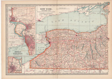
 1903 Large Colour Map NEW YORK Western Part BUFFALO NIAGARA ROCHESTER
-
$2.99 GBP
 1893 W & A.K. Johnston map of N.E. United States with S.E. U.S.A on reverse
-
$30.00 GBP
 British North America antique map Alexander Fullarton. Very fine!
-
$25.00 GBP
 VINTAGE ORIGINAL MAP-FROM "THE TIMES ATLAS OF THE WORLD"-SOUTH AMERICA -1922
-
$25.00 GBP
 1920 MAP OF NORTH-EASTERN CANADA Ontario Quebec Hudson Bay Plate 83 Times Atlas
-
$2.99 GBP
 1893 original map of United States (N.W. Central) with U.S.A. (N.W) on reverse
-
$40.00 GBP
 1783 ANTIQUE COPPER PLATE MAP CHARTS OF VARIOUS ISLANDS - AMERICA BERING ALASKA
-
$10.32 GBP
 1890 NORTH CAROLINA Map SOUTH CAROLINA Wall Art Antique Sepia Tone Decor
-
$9.99 GBP
 MILWAUKEE City Street Plan - 1909 Mounted Antique Map United States USA
-
$6.50 GBP
 1902 state Map of New Jersey United States antique vintage Britannica 10th
-
$12.36 GBP
 1903 South Carolina state map. Eastern United States. Columbia, Charleston.
-
$2.99 GBP
 Antique Map CANADA & NEWFOUNDLAND 1903 Looks Great Framed
-
$25.00 GBP
 VINTAGE ORIGINAL MAP-FROM "THE TIMES ATLAS OF THE WORLD"-CHINA-POLITICAL-1922
-
$70.00 GBP
 1784 ORIGINAL ANTIQUE COPPER PLATE CHART MAP - HARRISON - N.W. COAST AMERICA
-
$44.00 GBP
 NORTH AMERICA IX, MISSOURI, ILLINOIS, INDIANA, original antique map, SDUK, 1844
-
$6.50 GBP
 c1856 Map of Principal Cities and Ports in Canada antique vintage engraving
-
$19.99 GBP
 1897 Vermont & Rhode Island Original Antique Map by A & C Black
-
$12.00 GBP
 VINTAGE MAP P. 1-2 -PHILIPS INTERNATIONAL ATLAS-WORLD IN HEMISPHERES-1935
-
$3.99 GBP
 1893W & A.K. Johnston antique map of Manitoba with Saskatchewan on reverse
-
$23.02 GBP
 1934 Map Virginia County Township Railroads Richmond Norfolk Appomattox Pulaski
-
$12.89 GBP
 1903 antique New York state map. United States. The Empire State. 119 years old.
-
$49.95 GBP
 1780 LARGE ANTIQUE COPPER PLATE MAP HARRISON - RIVER ST LAWRENCE CANADA
-
$12.90 GBP
 1903 Maryland and Delaware state map. United States. Washington DC & Baltimore.
-
$75.00 GBP
 NORTH AMERICA c1804 BY JOHN RUSSELL GENUINE ANTIQUE ENGRAVED MAP
-
$12.00 GBP
 VINTAGE MAP PAGE 89-90-PHILIPS INTERNATIONAL ATLAS-INDIAN EMPIRE-SOUTH-1935
-
$11.33 GBP
 1903 New York state map. United States. The Empire State. Buffalo & Niagara.
-
$12.36 GBP
 1903 North Carolina state map. Eastern United States. Raleigh, Charlotte.
-
$14.99 GBP
 Encyclopaedia Britannica Map 1903 Florida United States
-
$9.99 GBP
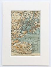 NEW YORK Area Plan - 1909 Mounted Antique Map - United States USA AMERICA
-
$8.00 GBP
 Antique Johnson's Indiana USA Atlas Map
-
$7.93 GBP
 Antique Map 1890 Massachusetts Rhode Island Connecticut or Vermont New Hampshire
-
$14.35 GBP
 New jersey - Original 1891 Map by Hunt & Eaton. Antique
-
$6.50 GBP
 c1856 Wellington Channel, Melville Island Canada antique vintage engraving
-
$25.00 GBP
 The Americas, 2 fine maps from 1868 by John Dower
-
$36.62 GBP
 1887 Plat Map ~ KANOPOLIS, WILSON, NEW ALBANY, KS / WILSON Co. on Reverse #291
-
$39.84 GBP
 Large Format 1905 COLOR Rand McNally Map Atlas Page Xiv & Xv Chinese Empire
-
$19.99 GBP
 1884 East Canada & Newfoundland Hand Coloured Original Antique Map by Johnston
-
$12.84 GBP
 1903 Pennsylvania state map. United States. Philadelphia cut in. Antique Map.
-
$19.99 GBP
 1863 Lower Canada Original Antique Hand Coloured Weekly Dispatch Map
-
$19.99 GBP
 1899 British North America Canada Original Antique Map by Richard Andree


