
-
$60.00 GBP

 1882 Map of the Rovuma River Tanzania Mozambique antique vintage
-
$150.00 GBP
 1690 Carel Allard France/Luxembourg Rare Antique Hand-coloured Copper Engraving
-
$60.00 GBP
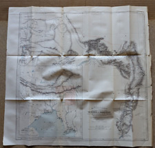 1882 Map of Sources Irawadi River Pundit Journey Tibet Assam antique vintage
-
$49.99 GBP
 1795 Chester City Plan Original Antique Map by John Stockdale
-
$55.00 GBP
 KENT ROMNEY MARSH BY WILLIAM MUDGE c1816 GENUINE 1st EDITION ORDNANCE SURVEY MAP
-
$13.99 GBP
 Antique Map Britannia Antiqua Ancient Britain C1870's Map Of The World
-
$29.99 GBP
 1673 MAP OF MONMOUTHSHIRE BY RICHARD BLOME WITH COLOUR CARTOUCHE MOUNMOUTHSHIRE
-
$5.00 GBP
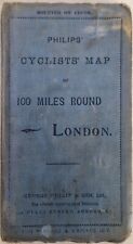 Philips' Cyclists' Map Of 100 Miles Round London Pub By George Philip & Son Ltd
-
$150.00 GBP
 ISLE OF WIGHT BY WILLIAM MUDGE c1810 GENUINE 1st EDITION ORDNANCE SURVEY MAP
-
$4.99 GBP
 ANTIQUE 1918 LONG LONDON STREET MAP ROTHERHITHE ACROSS TO SHEPHERDS BUSH
-
$48.00 GBP
 ROBERT MORDEN - EAST RIDING OF YORKSHIRE CAMDENS BRITANNIA 1695 FRAMED VGC
-
$12.00 GBP
 Bacon's new chart of north and central England map
-
$15.99 GBP
 ANCIENT & CLASSICAL MAP AFRICA ANTIQUA MAURITANIA INSET ROMA ET CARTHAGO 1905
-
$59.99 GBP
 Original 1930 Pratts High Test Map of The Great North Road
-
$40.00 GBP
 1882 Map of the Nguru mountain district Tanzania coast antique vintage
-
$40.00 GBP
 1885 Antique map of Dublin Bay Ireland - Virtue & Co Ltd 13" x 10.5"
-
$25.00 GBP
 1882 Preliminary Map of Wrangell Island antique vintage
-
$45.00 GBP
 ROBERT MORDEN - NORTH RIDING OF YORKSHIRE CAMDENS BRITANNIA 1695 FRAMED.
-
$6.95 GBP
 GEOGRAPHIA LARGE SCALE PAPER ROAD MAP OF 50 MILES ROUND BOURNEMOUTH - C. 1930
-
$7.95 GBP
 GEOGRAPHIA 2":1 Mile FOOTPATH MAP OF COUNTRY AROUND EASTBOURNE - 1938
-
$9.95 GBP
 Ordnance Survey Road Map Liverpool, Manchester and Chester 1919
-
$120.00 GBP
 1854 Large Map of Crimea Sebastopol Linen Backed Colour Crimean War J Arrowsmith
-
$175.00 GBP
 KENT CANTERBURY BY WILLIAM MUDGE c1819 GENUINE 1st EDITION ORDNANCE SURVEY MAP
-
$120.00 GBP
 HAMPSHIRE NORTH BY WILLIAM MUDGE c1817 GENUINE 1st EDITION ORDNANCE SURVEY MAP
-
$4.95 GBP
 THE OPERATIONS OF SECOND BRITISH ARMY WEST OF THE ORNE 10-18 JULY 1944, WW2 Map
-
$3.50 GBP
 Bacons County Map Gloucester For Cyclists & Tourists c 1910 11
-
$13.99 GBP
 Antique Print Map Of China Proper Dated C1870's Map Of Asia World Map
-
$12.50 GBP
 Ordnance Survey One Inch Cloth Map 118 Barnstable Exmoor Mounted Sections 1926
-
$50.00 GBP
 Cheshire Map of Chester by Rob Morden c1695 Copperplate Engraving Hand Painted
-
$147.45 GBP
 1913 Directory Of Salem Massachusetts With Folded Map Henry M Meek Publishing Co
-
$25.00 GBP
 1885 Antique Map of France Belgium & Netherlands - Virtue & Co Ltd 13" x 10.5"
-
$40.00 GBP
 1882 Map of the Mozambique coast antique vintage
-
$25.00 GBP
 1750'S ANTIQUE COPPER PLATE MAP - HUNGARY & TRANSYLVANIA - JOHN GIBSON
-
$5.00 GBP
 WAR OFFICE 1940 NORTHWICH & MACCLESFIELD Ordnance Survey Military Canvas Map
-
$8.99 GBP
 Portsmouth Isle of Wight No. 38 CLOTH Ordnance Survey Map Half Inch 1901 1926
-
$11.99 GBP
 SAN FRANCISCO City Street Plan - 1909 Mounted Antique Map - United States USA
-
$2.99 GBP
 ANTIQUE 1918 LONDON STREET MAP STRAND, HOLBORN & BLOOMSBURY REMOVED FROM BOOK
-
$14.99 GBP
 Bartholomew's Survey Map of CHESHIRE (c1910) Sheet 12 England, Folding Cloth Map
-
$59.00 GBP
 AN ANTIQUE (c mid 1800s) CANVAS BACKED FRENCH MAP. 'CARTE GEOLOGIQUE HISTORICAL'
-
$55.79 GBP
 HEC Robinson 71 x 96 cm Color Relief Wall Map - 1941 EAST INDIES Spratly Isles
-
$5.00 GBP
 WAR OFFICE 1940 WORCESTER England Ordnance Survey Military Edition Canvas Map
-
$15.00 GBP
 Ordnance Survey Cheshire Cloth Map Sheet SJ 47 Property of BMNH 1952
-
$7.99 GBP
 Vintage Ordnance Survey Map of Briton and Eastbourne 134 - 1920
-
$45.00 GBP
 1760 ANTIQUE COPPER PLATE MAP - CORRECT CHART OF THE IRISH SEA - GIBSON
-
$4.95 GBP
 FIRST CANADIAN ARMY OPERATIONS, CAEN-FALAISE 7-8 AUGUST 1944, WW2 OVERLORD Map
-
$250.00 GBP
 Antique Ordnance Survey Map - The Campo Of Gibraltar - 1912
-
$35.00 GBP
 1904 JOHNSTON'S RUSSO-JAPANESE WAR MAP China Formosa Japan Folding Map
-
$11.50 GBP
 OS Ordnance Survey One Inch Cloth Map 30 1911 Colchester
-
$145.00 GBP
 c1900 Panoramic Map Brighton Sussex Lewes South Downs Pictorial Antique Johnson
-
$12.99 GBP
 Large vintage 1956 road map of India, ceylon
-
$5.00 GBP
 1924 LAND'S END and LIZARD Cornwall - Ordnance Survey Contoured Cloth Map #146
-
$10.00 GBP
 Vintage Deutscher German Touring-Club Large Dissected Cloth Map - Nurnberg
-
$40.00 GBP
 1809 ANTIQUE MAP - CHART POSITION OF FRENCH FLEET IN AIX ROADS - NAPOLEONIC WARS
-
$3.75 GBP
 Bacons Cycling Road Map Leamington District c 1910-20 10
-
$10.50 GBP
 Ordnance Survey Tourist Map of The Lake District 1930s - cloth webbed map
-
$9.99 GBP
 1900 Gall & Inglis / Cary: Dumfries District Map, Scotland
-
$14.99 GBP
 Ordnance Survey Map England & Wales Large Sheet Series Sheet 5 South Wales 1913
-
$55.00 GBP
 Stanford's Road and Railway Map of Scotland - 1858 - 24 Panels Laid On Linen
-
$9.99 GBP
 New Reduced Survey Map of Glasgow & Clyde John Bartholomew Tourist 4 Mile inch
-
$99.99 GBP
 ARCTIC CIRCLE & NORTH WEST PASSAGE of Cap McCLURE - 1856 Antique Map
-
$7.99 GBP
 BELGIUM - 1910 Antique Colour Folding Map
-
$24.95 GBP
 1759 ANTIQUE COPPER PLATE MAP - KINGDOM OF BOHEMIA - ROLLOS / VAUGONDY
-
$20.00 GBP
 19th Century Map of Northamptonshire Edward Stanford HAND COLOURED Ordnance
-
$48.00 GBP
 A Complete Boxed Set of Bartholomew's Quarter Inch Maps of England & Wales c1910
-
$11.99 GBP
 PHILADELPHIA City Street Plan - 1909 Antique Map - United States USA America
-
$5.00 GBP
 The Graded Road Maps Of Scotland - Galloway & S. Ayrshire By Gall & Inglis
-
$37.00 GBP
 ORIGINAL Pratts High Test Map of The Great North Road Alfred E Taylor 1930 38X93
-
$14.99 GBP
 1910 Gall & Inglis / Cary: Easton's Touring & Motoring Map of Peebles & District
-
$15.00 GBP
 Daily Express War Map of Belgium and Holland. 1940. Philip. London Geographical
-
$3.99 GBP
 THE DEVELOPMENT OF ALLIED OPERATIONS EAST OF THE RHINE March/April 1945 WW2 Map
-
$39.99 GBP
 Walker's DEVONSHIRE, antique folding map, J & C Walker circa 1840s, Devon
-
$11.99 GBP
 LOS ANGELES City Street Plan 1909 Mounted Antique Map United States USA America
-
$3.50 GBP
 OPERATIONS TO CLEAR TYHE WEST BANK OF THE RIVER MAAS 1944, WW2 Map
-
$3.99 GBP
 1970's BARTHOLOMEW HALF INCH MAP NORTH LANCASHIRE AND ISLE OF MAN
-
$7.95 GBP
 BACON'S 1":5 Miles CYCLING & MOTORING MAP OF TEIGNMOUTH DISTRICT - 1920
-
$15.94 GBP
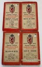 Lot of 4 Vintage Ordnance Survey SCOTLAND 1" Maps
-
$12.99 GBP
 1891 Map of London and environs - F.S. Weller / London, Cassell & Company
-
$3.50 GBP
 WELWYN GARDEN CITY Ordnance Survey 2½ Inch Map - 1:25000 Scale - 1962
-
$325.00 GBP
 Antique Map "Pianta Guida della Città di Roma" R. Bulla, 1885
-
$220.00 GBP
 1870 Very Large Map of France, Carte De L'Empire Français, E. Andriveau-Goujon
-
$24.99 GBP
 Vintage Aberdeen Town Plan by Bartholomew (1958) Folding Map, Scotland, Scottish
-
$35.00 GBP
 EDINBURGH: Huge Antique map Post Office boundaries history 1917 Leith Portabello
-
$29.95 GBP
 1758 ANTIQUE COPPER PLATE MAP - OLD MAP OF THE CONTINENT - JOHN GIBSON
-
$45.00 GBP
 1782 ANTIQUE CHART A NEW MAP OF THE WORLD IN THREE SECTIONS J BAYLY - NAVIGATORS
-
$13.99 GBP
 Antique Map Netherlands & Belgium Dated 1887 Europe Colour Map Of The World Art
-
$9.99 GBP
 1748 A CORRECT MAP OF BRECKNOCKSHIRE IN SOUTH WALES BY OSBORNE CRICKHOWEL *
-
$8.99 GBP
 New Reduced Ordnance Survey Map The Environs Of London John Bartholomew 2 Mile
-
$500.00 GBP
 1807 Folding Map of the ISLE OF WIGHT John Albin Printed by T Gardiner Second Ed
-
$46.99 GBP
 Philips Special Map of the Nile, Advance on Khartum & Environs of Omdurman c1898
-
$13.99 GBP
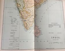 Antique Print Dated C1870's Map Of India Southern Part Asia Map Of The World
-
$22.00 GBP
 Vintage Map Grimsel Pass Switzerland Travel Guid, in German, by Kummerly & Frey
-
$4.99 GBP
 THE CLEARANCE OF THE ROERMOND TRIANGLE 15-28 January 1945, WW2 Map, US ARMY
-
$4.95 GBP
 THE ADVANCE TO THE ELBE and THE DRIVE TO THE BALTIC, April 1945, WW2 Map
-
$5.25 GBP
 THE BATTLE OF THE RHINE. 24-28 March 1945, WW2 Map
-
$5.00 GBP
 Bartholomew's DORSET Half-Inch Sheet 4 - 1948 Vintage Cloth Map
-
$5.00 GBP
 c1940 CIRENCESTER and The Surrounding District Map
-
$54.00 GBP
 Panorama of the Rhine (Panorama des Rheins), Delkeskamp, 1837
-
$4.99 GBP
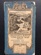 Hertford and Saffron Walden 1938 cloth Ordnance Survey map sheet 96, 1” series
-
$24.99 GBP
 1795 Cheshire Original Antique Map by John Stockdale
-
$20.00 GBP
 Antique Cycling Road Map Cambridge John Bartholomew & Co Ltd circa 1901


