
-
$34.99 GBP

 National Geographic Map - Antarctic Regions - 1932 - Vintage
-
$19.99 GBP
 National Geographic Map - West Indies and Central America - 1970 - Vintage
-
$14.99 GBP
 National Geographic Traveler's Map of Italy - 1970 - Vintage
-
$17.99 GBP
 National Geographic Map of The Heavens -Monthly Star Chart Both Hemispheres 1970
-
$6.99 GBP
 Admiralty Chart of Plymouth Sound, England South Coast. Printed 1971.
-
$7.99 GBP
 Admiralty Chart of Wembury Bay, England South Coast. Printed Circa 1970.
-
$14.99 GBP
 National Geographic Map - West Indies - 1954 - Vintage
-
$7.99 GBP
 Admiralty Chart of Persian Gulf KALAT & RA'S AL KHAFJI TO ABADAN. Printed 1970.
-
$7.99 GBP
 Admiralty Chart of Cow Head Harbour to St Genevieve Bay etc. Printed 1971?
-
$29.99 GBP
 1971 NORWAY BRANDS FJORD to LEKA Nautical SEA Navigation MAP Chart 28" x 41" B88
-
$19.99 GBP
 1971 BRAZIL East Coast RECIFE to RIO DOCE Admiralty Sea MAP Chart 28" x 46" C34
-
$19.99 GBP
 1972 ENGLAND WEST COAST Approaches BRISTOL CHANNEL Sea MAP Chart 28" x 41" B92
-
$19.99 GBP
 1970 West Coast SPAIN & PORTUGAL Admiralty Navigation Map 28" x 41" D67
-
$14.99 GBP
 1971 GABBARD & GALLOPER BANKS to HOOK of HOLLAND Sea Chart MAP 28" x 44" C09
-
$14.99 GBP
 1971 CANADA Saint Lawrence River (Above Quebec) Navigation Map 23½" x 41" B26
-
$9.99 GBP
 1971 NORTH SEA & BELGIUM Dunkirk to Flushing Sea Map Chart 28" x 41" B28
-
$50.00 GBP
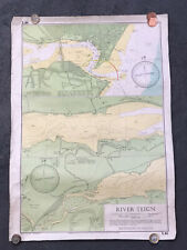 River Teign Admiralty Sea Chart Y43 (410mm X 580mm) - 1971 - Devon / Teignmouth
-
$14.99 GBP
 1972 LIBYA Mediterranean Sea EZ ZUEITINA - Navigation Chart MAP 28" x 20½" B84
-
$19.99 GBP
 1971 AUSTRALIA TASMANIA Port Dalrymple NAUTICAL Sea Chart MAP 28" x 44" B63
-
$19.99 GBP
 1970 BLAKENEY to FLAMBOROUGH HEAD Admiralty Map Sea Chart 28" x 46" B96
-
$19.99 GBP
 1971 West Coast SPAIN & PORTUGAL Admiralty Sea MAP CHART 28" x 41" C59
-
$19.99 GBP
 1970 AFRICA SE Coast PORT ST JOHN's To DURBAN Sea MAP CHART 28" x 41" C52
-
$19.99 GBP
 1971 CANADA St LAWRENCE RIVER Pointe Des Monts ADMIRALTY Map Chart 28" x 41" D63
-
$19.99 GBP
 1973 JAPAN NAIKAI ~ OSAKI KAMI SHIMA - NIIHAMA Sea MAP CHART 28" x 41" C37
-
$19.99 GBP
 1970 USA Delaware Bay to Cape Hatteras - Admiralty Map 28" x 41" D84
-
$19.99 GBP
 1972 CANADA Gulf St Lawrence NEWFOUNDLAND MAP CHART 40" x 37" C64
-
$19.99 GBP
 1972 AUSTRALIA QUEENSLAND Adolphus Channel Sea Chart MAP 28" x 41" B64
-
$29.99 GBP
 1971 ALGERIA & TUNISIA North Africa - Mediterranean Sea Chart MAP 28" x 41" C14
-
$19.99 GBP
 1971 BLAKENEY to FLAMBOROUGH HEAD Admiralty Map Sea Chart 28" x 46" B100
-
$19.99 GBP
 1970 SW SPAIN - BAHIA de CADIZ Admiralty Map Chart 28" x 41" D72
-
$29.99 GBP
 1971 GREECE Akra Killini to Akra Psaromita - ADMIRALTY Map Chart 28" x 41" D52
-
$19.99 GBP
 1971 GULF of SUEZ - RED SEA North Africa Navigation Sea MAP CHART 28" x 41" C47
-
$29.99 GBP
 1970 NORWAY - HELGOY to SOROY Admiralty Sea MAP CHART 28" x 41" D05
-
$19.99 GBP
 1971 SW NORWAY COAST The NAZE ~ KARMO Navigational SEA Chart MAP 28" x 41" B69
-
$19.99 GBP
 1971 South TURKEY - GELIDONYA BURNU to ANAMUR Admiralty Map Chart 28" x 41" D53
-
$24.99 GBP
 1971 Spain & Italy BARCELONA to NAPOLI ~ Admiralty Map Chart 28" x 41" D47
-
$29.99 GBP
 1971 SW NORWAY COAST - THE NAZE ~ KARMO Navigational SEA Chart MAP 28" x 41" B58
-
$29.99 GBP
 1970 8 PORTS & BAYS on NORTH & EAST COAST of IRELAND Sea Map Chart 28" x 41" A73
-
$24.99 GBP
 1971 AUSTRALIA East Coast QUEENSLAND PORT CURTIS - Sea MAP CHART 28" x 41" B41
-
$23.99 GBP
 GUADELOUPE MAP CHART ON BROCHURE 1971 200 X 200 MM p&o guide
-
$29.99 GBP
 1972 NE Coast NEWFOUNDLAND St John Bay - Belle Isle NAVIGATION MAP 28" x 41" B82
-
$6.75 GBP
 Ordnance Survey North Midlands & Yorkshire Sheet 11 1977
-
$40.00 GBP
 Laminated Wall Map of Arabian Peninsula 1975
-
$38.50 GBP
 SUPERB 1970 FACSIMILE PRINT GONZALO JIMENEZ DE QUESADA CONQUISTADOR GRANADA
-
$31.99 GBP
 1962 Vintage Old Soviet Moscow City Map
-
$21.99 GBP
 1971 Vintage Soviet Moscow VDNH USSR map
-
$2.99 GBP
 Bartholomew Half Inch Map No 37 Galloway Scotland 1971


