 Antiques (UK)
Africa Maps
Asia Maps
Australia/Oceania Maps
Celestial Maps
Central America/Caribbean Maps
Curiosities Maps
Digital Maps
Europe Maps
Map & Globe Mixed Lots
Map & Globe Reproductions
North America Maps
South America Maps
World & Celestial Globes
World Maps

-
$110.00 GBP

 Topographical Map of the County of Kent - 1769 Reproduction - Rare Large Book
-
$150.00 GBP
 London ST. PAULS CATHEDRAL Three original engravings by J. Kip ca 1720
-
$249.99 GBP
 1728 VERY RARE Herman Moll Map , Genuine Antique, The Persian Empire
-
$25.00 GBP
 Original Antique 1787 Copper Plate Engraved Map Of Somerset By JOHN CARY.
-
$60.00 GBP
 London St Andrews Holborn Parish Original engraving by Blome ca 1720
-
$20.00 GBP
 Devonshire, 1784 county map, genuine antique 240 years old!
-
$49.00 GBP
 ANTIQUE 18TH CENTURY PLAN OF THE NAVIGABLE CANAL COVENTRY TO STAFFORDSHIRE
-
$55.00 GBP
 Antique map of Surrey by Richard Blome 1715
-
$14.99 GBP
 MAP OF KENT CIRCA 1700'S 48 x 36cm 1970'S REPRODUCTION
-
$27.45 GBP
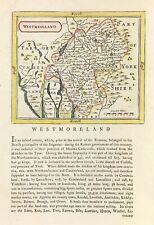 Westmoreland map By Seller & Grose Original engraved hand colour 1777
-
$49.99 GBP
 Rare Essex Pt Map (1777) Strethall, Heydon, Langley - John Chapman & Peter Andre
-
$10.00 GBP
 Reproduction Antique Map Of Suffolk 1787 - From The Cary County Collection
-
$75.00 GBP
 EUROPE EUROPA BY NICOLAS SANSON c1794 GENUINE COPPER ENGRAVED MAP
-
$175.00 GBP
 1794 Country Around Manchester Large Folding Map by Stockdale 84 cm x 81 cm
-
$249.99 GBP
 1728 VERY RARE Herman Moll Map , Genuine Antique, Greece Asia Middle East
-
$20.00 GBP
 1794 Buckinghamshire Original Antique Map by Thomas Conder
-
$45.00 GBP
 Antique map of Warwickshire by Richard Blome 1715
-
$75.00 GBP
 1732 map. Britannia Saxonica. Rapin de Thoyras. Outstanding!
-
$6.99 GBP
 VINTAGE MAP PRINT READY FOR FRAMING OF ANTIQUE 1715 THE TOTIUS EUROPE LITTORA
-
$29.00 GBP
 Antique Map of Scotland "L'Ecosse" after Pierre Vander Aa Etching Limited Print
-
$24.00 GBP
 London to Richmond, John Cary 1790 Antique Road Street Map Inns Parks
-
$45.00 GBP
 c1760 French Map By Bellin - Great Yarmouth Norfolk Plan De La Ville Et Environs
-
$20.00 GBP
 Hampshire, 1784 county map, genuine antique 240 years old!
-
$18.00 GBP
 Kingdom Of Prussia Map By Thomas Kitchin 1763
-
$45.00 GBP
 Antique 18th century Nottinghamshire Map Robert Morden lot LH22
-
$60.00 GBP
 London The TOWER Liberty. Original engraving by Blome ca 1720
-
$18.90 GBP
 London antique panorama view plan map 1720 Londinium Londinum art poster print
-
$29.99 GBP
 Antique 1736 double sided framed Map of The Road from Bristol to Worcester
-
$249.99 GBP
 1728 VERY RARE Herman Moll Map , Genuine Antique, Cyrus The Great Persia
-
$150.00 GBP
 100% ORIGINAL LARGE WORCESTER CITY MAP BY VALENTINE GREEN C1795 HAND COLOURED
-
$249.99 GBP
 1728 VERY RARE Herman Moll Map , Genuine Antique, Justin’s Map Of The World
-
$325.00 GBP
 Taylor and Skinner Survey and Maps of Scotland 1776
-
$45.00 GBP
 Antique map of Lancashire by Richard Blome 1715
-
$14.99 GBP
 MAP OF BUCKINGHAMSHIRE ROBERT MORDEN 1722 46 x 38cm 1970'S REPRODUCTION
-
$29.99 GBP
 Framed Picture Of 1787 Buckinghamshire Map By John Cary Engraver 29.5 x 34.5 cm
-
$40.00 GBP
 Antique map of Berkshire by Richard Blome 1715
-
$40.00 GBP
 Antique map of Northamptonshire by Richard Blome 1715
-
$95.00 GBP
 Antique map HOO, CHATHAM, GILLINGHAM, High Halstow, Allhallows, Kent Hasted 1778
-
$249.99 GBP
 1728 VERY RARE Herman Moll Map , Genuine Antique, Ancient Greek Trojan War
-
$249.99 GBP
 1728 VERY RARE Herman Moll Map , Genuine Antique, Voyage Of Aeneas Greece
-
$45.00 GBP
 Antique map of Surrey by John Seller 1701
-
$40.00 GBP
 The North West Part of the John Rocque Map of Middlesex 1754
-
$7.00 GBP
 c1789 John Cary Map of Suffolk Colour Southwold Highlighted
-
$40.00 GBP
 Road Map John Senex Winchester Ringwood Poole Lymington Christchurch Southampton
-
$45.00 GBP
 Antique Map KENT & FRANCE with Roman/Saxon placenames Edward Hasted c1780
-
$99.00 GBP
 London, Southwark, St. Saviours, St. Georges, Stow's Survey, John Strype 1720
-
$195.00 GBP
 A New Map of North America. Thomas Conder. 18th Century Original
-
$101.00 GBP
 Rutlandshire map 1722 by Robert Morden Original on laid paper hand color
-
$75.00 GBP
 Emanuel Bowen : A Map of Cornwall. 1720
-
$55.00 GBP
 Antique map of Dorset by Richard Blome 1715
-
$55.00 GBP
 Antique map of Hampshire by Richard Blome 1715
-
$25.00 GBP
 1737 ORIGINAL ANTIQUE COPPERPLATE MAP FLANDERS SPANISH NETHERLANDS - HERMAN MOLL
-
$65.00 GBP
 ARMS OF THE COLLEGES CAMBRIDGE BY EMANUEL BOWEN c1720 GENUINE ANTIQUE ENGRAVING
-
$45.00 GBP
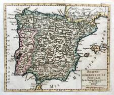 SPAIN AND PORTUGAL BY ROBERT DE VAUGONDY c1794 GENUINE ANTIQUE ENGRAVED MAP
-
$6.00 GBP
 1720 Antique Road Map Maidenhead Henley Dorchester Abingdon ex-Britannia Depicta
-
$45.00 GBP
 Antique map of Oxfordshire by Richard Blome 1715
-
$55.00 GBP
 Antique map of England by Richard Blome 1715
-
$42.75 GBP
 Africa and Mediterranean map 1800 engraved coloured by Wilkinson
-
$44.95 GBP
 Robert Morden Map Westmorland 1708 Lake District Antique Cumbria Historical VGC
-
$65.00 GBP
 Antique map of Cornwall by Alexander Hogg and Thomas Conder 1784
-
$50.00 GBP
 Antique map of Suffolk by Richard Blome 1715
-
$20.00 GBP
 Gloucestershire, 1784 county map, genuine antique 240 years old!
-
$9.99 GBP
 OLD COPY OF ANTIQUE MAP 1700'S ISLANDS OF SCILLY 1689
-
$24.99 GBP
 DEVON CORNWALL PLYMOUTH LOOE BY EMANUEL BOWEN c1720 GENUINE ANTIQUE MAP
-
$45.00 GBP
 Antique map of Leicestershire by Richard Blome 1715
-
$15.00 GBP
 Westmoreland, 1784 county map, genuine antique 240 years old!
-
$35.00 GBP
 1760'S ANTIQUE COPPERPLATE MAP INDOSTAN GREAT MOGOLS EMPIRE INDIA - T KITCHIN
-
$18.00 GBP
 OLD ANTIQUE MAP SCILLY ISLES c1830 ENGRAVING by JOHN CARY ORIGINAL HAND COLOUR
-
$50.00 GBP
 Antique map of Cheshire by Richard Blome 1715
-
$48.00 GBP
 POLAND, LITHUANIA, John Senex original antique map 1749
-
$145.00 GBP
 Antique Map HOO, CHATHAM, GILLINGHAM,High Halstow,Allhallows,Kent E.Hasted 1778
-
$27.00 GBP
 Worcestershire Shropshire 1720 Montgomeryshire Owen & Bowen map antique
-
$14.99 GBP
 1720 Antique Map, Brecknockshire, Wales - Owen & Bowen
-
$75.00 GBP
 Antique map of Cornwall by Richard Blome 1715
-
$24.95 GBP
 1700'S ANTIQUE COPPER PLATE MAP - ANCIENT ARABIA PETRAEA ET DESERTA - CELLARIUS
-
$93.10 GBP
 Pacific Islands map 1790 of Capt's Discoveries Rigobert Bonne original colour
-
$40.00 GBP
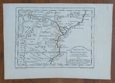
 Antique map of Monmouthshire by Richard Blome 1715
-
$8.00 GBP
 1770 London - Aylesbury & London Arundel Chichester 2 x Kitchin Ribbon Road Maps
-
$26.80 GBP
 London to Montgomery Evesham Worcester Ludow Bishop Castle 1872 map
-
$15.00 GBP
 Framed Antique 1738 Map Of Buckinghamshire, The Road From London to Yarmouth.
-
$11.99 GBP
 Owen and Bowen Original County Map of Cumberland and Strip Road Map. c.1720
-
$115.00 GBP
 Antique Map "The North Part of Italy" Herman Moll, c.1711
-
$28.00 GBP
 ANTIQUE 18TH CENTURY AFRICA MAP ZIMBABWE MOZAMBIQUE EAST AFRICA 1770 BELLIN
-
$50.00 GBP
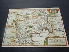 Antique map of Middlesex by Richard Blome 1715
-
$35.50 GBP
 Buckinghamshire map by Thomas Kitchin Original copper engraved 1748
-
$135.00 GBP
 Antique Map BROMLEY, BECKENHAM HUNDRED Chislehurst Knockholt Kent, Hasted 1778
-
$9.99 GBP
 OLD COPY OF MAP MARINE CHART OF THE ENGLISH CHANNEL 1700'S
-
$19.99 GBP
 City of York Plan 1775 - repro map T. Jefferys 46x39cm, 18x15ins, old / vintage
-
$24.99 GBP
 1795 West Yorkshire Original Antique Map by John Stockdale
-
$35.00 GBP
 Antique map of Warwickshire by Alexander Hogg and Thomas Conder 1784
-
$26.99 GBP
 LONDON SURREY EPSOM SUSSEX BRIGHTON BY PATERSON c1785 GENUINE ANTIQUE MAP
-
$45.00 GBP
 1748 ANTIQUE COPPER PLATE MAP - CHINA KOREA - L'EMPIRE DE LA CHINE - BELLIN
-
$29.99 GBP
 NORFOLK NORWICH YARMOUTH KINGS LYNN BY EMANUEL BOWEN c1720 GENUINE ANTIQUE
-
$14.99 GBP
 1797 LONDON & WESTMINSTER MAP PLAN JOHN FAIRBURN GUILDHALL LIBRARY 68 X 48cm
-
$40.00 GBP
 A scarce antique copperplate map of Kent by John Cowley c1744
-
$12.00 GBP
 Aldersgate Ward, London, original antique plan published c1756
-
$19.99 GBP
 East Riding of Yorkshire County Map by Herman Moll 1724 - Reproduction
-
$500.00 GBP
 Superb CASSINI'S 1790 TERRESTRIAL GLOBE 13 inch + Stand GREAVES & THOMAS
-
$249.99 GBP
 1728 VERY RARE Herman Moll Map , Genuine Antique, GREECE
-
$19.99 GBP
 1795 The Huddersfield Narrow Canal To Ashton Under Lyne Original Antique Map


